Kensico Reservoir fishing map is available as part of iBoating : USA Marine & Fishing App(now supported on multiple platforms including Android, iPhone/iPad, MacBook, and Windows(tablet and phone)/PC based chartplotter.).
With our Lake Maps App, you get all the great marine chart app features like fishing spots, along with Kensico Reservoir depth map. The fishing maps app include HD lake depth contours, along with advanced features found in Fish Finder / Gps Chart Plotter systems, turning your device into a Depth Finder. The Kensico Reservoir Navigation App provides advanced features of a Marine Chartplotter including adjusting water level offset and custom depth shading. Fishing spots and depth contours layers are available in most Lake maps. Lake navigation features include advanced instrumentation to gather wind speed direction, water temperature, water depth, and accurate GPS with AIS receivers(using NMEA over TCP/UDP). Autopilot support can be enabled during ‘Goto WayPoint’ and ‘Route Assistance’.
Now i-Boating supports Fishing Points in Kensico Reservoir.
Have more questions about the Nautical Chart App? Ask us.
Fishing Info for Kensico Reservoir
The Kensico Reservoir is a reservoir spanning the towns of Armonk (North Castle) and Valhalla (Mount Pleasant), New York, located 3 miles (5 km) north of White Plains. It was formed by the original earth and gravel Kensico Dam constructed in 1885, which impounded waters from the Bronx and Byram rivers. In 1917, a new masonry dam was completed, replacing the old dam and expanding the water supply by bringing water from the Catskill Mountains over a distance of more than 100 miles. The reservoir mainly serves to store waters received from the Catskill Mountains west of the Hudson River. Along with the West Branch Reservoir and Boyds Corner Reservoir, it is one of three reservoirs within the Catskill/Delaware system outside the Catskill Mountains region. The other two reservoirs are the Hillview Reservoir and the Jerome Park Reservoir. The Kensico Reservoir also hosts fishing and boating recreation. Every year, the reservoir is stocked with over 2,000 brown trout. In April 2016, the Kensico Reservoir was stocked with 8,620 brown trout 8.5 to 9.5 inches (22 to 24 cm) long.
More on Wikipedia...Popular fish species in this lake include Lake trout, Largemouth bass and Smallmouth bass.
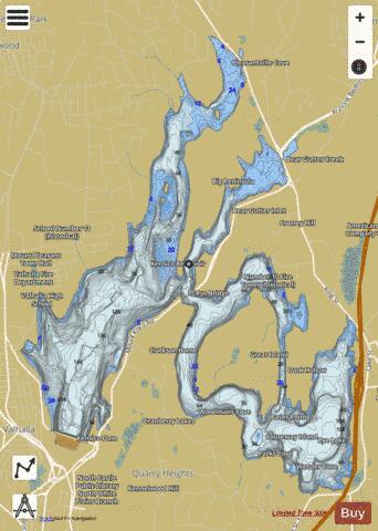
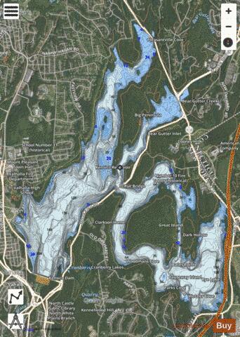
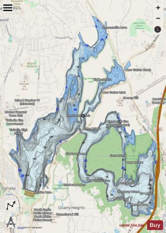
Kensico Reservoir Fishing Map Stats | |
| Title | Kensico Reservoir |
| Scale | 1:6000 |
| Counties | Westchester |
| Nearby Cities | North White Plains, Armonk, Mount Pleasant, Purchase, Hawthorne, Thornwood, East White Plains, North Castle, White Plains, Chappaqua |
| Area * | 2162.67 acres |
| Shoreline * | 32.24 miles |
| Min Longitude | -73.78 |
| Min Latitude | 41.07 |
| Max Longitude | -73.72 |
| Max Latitude | 41.12 |
| Edition Label 1 | |
| Edition Label 2 | |
| Edition Label 3 | |
| Id | US_CC_NY_kensico_ny |
| Country | US |
| Projection | Mercator |
| * some Stats may include nearby/connecting waterbodies | |
|