Great Herring Pond fishing map is available as part of iBoating : USA Marine & Fishing App(now supported on multiple platforms including Android, iPhone/iPad, MacBook, and Windows(tablet and phone)/PC based chartplotter.).
With our Lake Maps App, you get all the great marine chart app features like fishing spots, along with Great Herring Pond depth map. The fishing maps app include HD lake depth contours, along with advanced features found in Fish Finder / Gps Chart Plotter systems, turning your device into a Depth Finder. The Great Herring Pond Navigation App provides advanced features of a Marine Chartplotter including adjusting water level offset and custom depth shading. Fishing spots and depth contours layers are available in most Lake maps. Lake navigation features include advanced instrumentation to gather wind speed direction, water temperature, water depth, and accurate GPS with AIS receivers(using NMEA over TCP/UDP). Autopilot support can be enabled during ‘Goto WayPoint’ and ‘Route Assistance’.
Now i-Boating supports Fishing Points in Great Herring Pond.
Have more questions about the Nautical Chart App? Ask us.
Fishing Info for Great Herring Pond
Great Herring Pond is a 376-acre (1.5 km2) warm water pond mostly located in Plymouth, Massachusetts, with the southern portion extending into Bourne. The village of Pondville in the Cedarville section of Plymouth lies on the eastern shore of the pond. The pond has an average depth of 20 ft (6 m) and a maximum depth of 42 ft (13 m). The bottom is composed of sand, rubble and muck. A tire reef was installed in 1979 toprovide additional fish shelter. The inflow comes from Little Herring Pond, and the outflow goes into the in Bourne. The Public Access Board gravel ramp in Bourne enters shallow water and is therefore best suited for canoes, inflatable and other shallow-draft, hand-carried craft. There has been multiple sightings of massive turtles on Great Herring Pond. They have been seen to be in size of 4–5 feet long, with heads the size of footballs. They have been seen floating down stream from Little Herring Pond, under Carters Bridge. In colonial days, a large village of Christian Indians lived nearby in a place called Comassekumkanet, which means "on the other side of the prince's house" in Algonquin. Thomas Tupper, an early settler, preached to them though he was not ordained.
More on Wikipedia...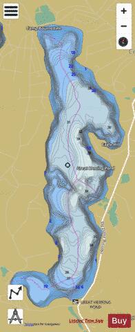
Great Herring Pond Fishing Map Stats | |
| Title | Great Herring Pond |
| Scale | 1:6000 |
| Counties | Barnstable, Plymouth |
| Nearby Cities | Sagamore, Bourne, Buzzards Bay, White Island Shores, Sandwich, Monument Beach, The Pinehills, Onset, Pocasset, Forestdale |
| Area * | 414.74 acres |
| Shoreline * | 5.54 miles |
| Min Longitude | -70.57 |
| Min Latitude | 41.79 |
| Max Longitude | -70.56 |
| Max Latitude | 41.81 |
| Edition Label 1 | |
| Edition Label 2 | |
| Edition Label 3 | |
| Id | US_CC_MA_00616296 |
| Country | US |
| Projection | Mercator |
| * some Stats may include nearby/connecting waterbodies | |
|