Long Pond fishing map is available as part of iBoating : USA Marine & Fishing App(now supported on multiple platforms including Android, iPhone/iPad, MacBook, and Windows(tablet and phone)/PC based chartplotter.).
With our Lake Maps App, you get all the great marine chart app features like fishing spots, along with Long Pond depth map. The fishing maps app include HD lake depth contours, along with advanced features found in Fish Finder / Gps Chart Plotter systems, turning your device into a Depth Finder. The Long Pond Navigation App provides advanced features of a Marine Chartplotter including adjusting water level offset and custom depth shading. Fishing spots and depth contours layers are available in most Lake maps. Lake navigation features include advanced instrumentation to gather wind speed direction, water temperature, water depth, and accurate GPS with AIS receivers(using NMEA over TCP/UDP). Autopilot support can be enabled during ‘Goto WayPoint’ and ‘Route Assistance’.
Now i-Boating supports Fishing Points in Long Pond.
Have more questions about the Nautical Chart App? Ask us.
Fishing Info for Long Pond
Long Pond is a 1,721-acre (7.0 km2) lake within the towns of Lakeville and Freetown, in southeastern Massachusetts. It shares its waters with Assawompset Pond. These lakes provide a source of drinking water to the city of New Bedford, the largest city in southeastern Massachusetts. Long Pond is roughly one mile (1.6 km) wide by four miles (6.4 km) miles long, and contains three islands within its boundaries. In 1894 Assawompset Pond was dammed, increasing the water depth of Long Pond (which is connected by a small river) by about five feet (1.5 m). This created Nelson Island and caused Sunken Island to disappear due to erosion. All that remains of Sunken Island are the rocks in a shallow area just to the northwest of Lewis Island. Lewis Island is the largest of the three remaining islands today, containing sixteen privately owned cottages, while the second largest island, Nelson Island, was purchased in 2005 and now is a year-round private residence. The smallest island, Goat Island, was recently purchased from the Boy Scouts by a private citizen. Along the perimeter of the lake are many homes and private access points to the waterfront. Long Pond is well known for fishing and boating. At the northeast corner of the lake is a canal that meanders through the Parkhurst development and is navigable by boat. There is a small bridge that allows foot and road traffic onto the artificial island. In the northwest corner of the lake is a river that feeds into Assawompset Pond, which winds through the marshland before passing under Route 18 and connecting with Assawompset. It is locally known as the "Snake River," but is also labeled as the Long Pond River on some maps.
More on Wikipedia...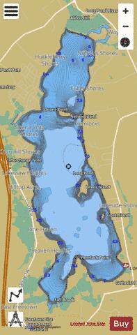
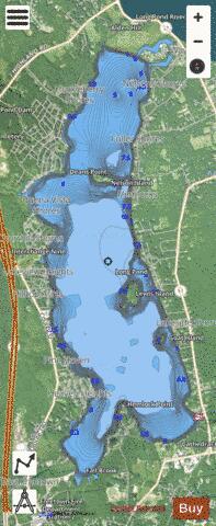
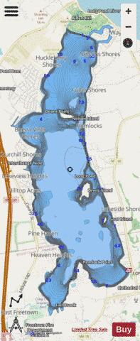
Long Pond Fishing Map Stats | |
| Title | Long Pond |
| Scale | 1:6000 |
| Counties | Bristol, Plymouth |
| Nearby Cities | Lakeville, Middleborough, Acushnet, Rochester, Berkley, New Bedford, Smith Mills, Raynham Center, Fairhaven, Taunton |
| Area * | 1743.07 acres |
| Shoreline * | 14.84 miles |
| Min Longitude | -70.96 |
| Min Latitude | 41.77 |
| Max Longitude | -70.93 |
| Max Latitude | 41.83 |
| Edition Label 1 | |
| Edition Label 2 | |
| Edition Label 3 | |
| Id | US_CC_MA_00613545 |
| Country | US |
| Projection | Mercator |
| * some Stats may include nearby/connecting waterbodies | |
|