Naknek Lake fishing map is available as part of iBoating : USA Marine & Fishing App(now supported on multiple platforms including Android, iPhone/iPad, MacBook, and Windows(tablet and phone)/PC based chartplotter.).
With our Lake Maps App, you get all the great marine chart app features like fishing spots, along with Naknek Lake depth map. The fishing maps app include HD lake depth contours, along with advanced features found in Fish Finder / Gps Chart Plotter systems, turning your device into a Depth Finder. The Naknek Lake Navigation App provides advanced features of a Marine Chartplotter including adjusting water level offset and custom depth shading. Fishing spots and depth contours layers are available in most Lake maps. Lake navigation features include advanced instrumentation to gather wind speed direction, water temperature, water depth, and accurate GPS with AIS receivers(using NMEA over TCP/UDP). Autopilot support can be enabled during ‘Goto WayPoint’ and ‘Route Assistance’.
Now i-Boating supports Fishing Points in Naknek Lake.
Have more questions about the Nautical Chart App? Ask us.
Fishing Info for Naknek Lake
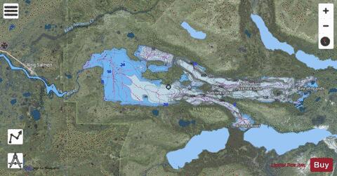
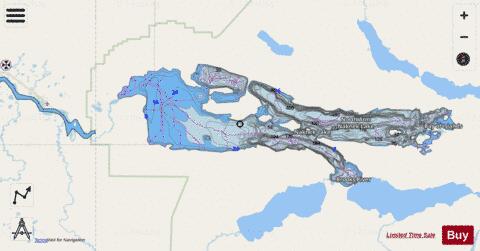
Naknek Lake is a lake in southern Alaska, near the base of the Alaska Peninsula. Located in Katmai National Park and Preserve, the lake is 40 miles (64 km) long and three to eight miles (4.8 to 12.9 km) wide, the largest lake in the park. The lake drains west into Bristol Bay through the Naknek River. The elevation of the lake has lowered over the past 5,000 years as it has cut through a glacial moraine, separating Naknek Lake and Brooks Lake and creating Brooks Falls about 3500 years ago. The earliest Russian explorer reported the lake's name as Naknek, but a later one said its name was "Akulogak". Ivan Petrof named the lake Lake Walker, for Francis Amasa Walker, Superintendent of the 1880 United States census. The lake is famous for its sport fishing, supporting one of the largest king salmon fisheries in southwestern Alaska, though the king salmon are greatly outnumbered by sockeye salmon as well as pink and chum salmon. Large rainbow trout are also common around the lake, along with northern pike, lake trout and Arctic char. Brooks Camp is located on the lake's shore where the Brooks River enters the lake over rapids.
More on Wikipedia...Popular fish species in this lake include Arctic char, Chum salmon, Lake trout, Northern pike and Rainbow trout.
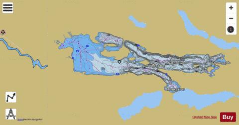
Naknek Lake Fishing Map Stats | |
| Title | Naknek Lake |
| Scale | 1:12000 |
| Counties | Bristol Bay, Lake and Peninsula |
| Nearby Cities | King Salmon, South Naknek, Kvichak, Naknek, Levelock, Koggiung, Igiugig, Libbyville |
| Area * | 77964.39 acres |
| Shoreline * | 115.70 miles |
| Min Longitude | -156.43 |
| Min Latitude | 58.54 |
| Max Longitude | -155.68 |
| Max Latitude | 58.74 |
| Edition Label 1 | |
| Edition Label 2 | |
| Edition Label 3 | |
| Id | US_AK_naknek_lake |
| Country | US |
| Projection | Mercator |
| * some Stats may include nearby/connecting waterbodies | |
|