Lake Wissota fishing map is available as part of iBoating : USA Marine & Fishing App(now supported on multiple platforms including Android, iPhone/iPad, MacBook, and Windows(tablet and phone)/PC based chartplotter.).
With our Lake Maps App, you get all the great marine chart app features like fishing spots, along with Lake Wissota depth map. The fishing maps app include HD lake depth contours, along with advanced features found in Fish Finder / Gps Chart Plotter systems, turning your device into a Depth Finder. The Lake Wissota Navigation App provides advanced features of a Marine Chartplotter including adjusting water level offset and custom depth shading. Fishing spots and depth contours layers are available in most Lake maps. Lake navigation features include advanced instrumentation to gather wind speed direction, water temperature, water depth, and accurate GPS with AIS receivers(using NMEA over TCP/UDP). Autopilot support can be enabled during ‘Goto WayPoint’ and ‘Route Assistance’.
Now i-Boating supports Fishing Points in Lake Wissota.
Have more questions about the Nautical Chart App? Ask us.
Fishing Info for Lake Wissota
Lake Wissota is a reservoir in Chippewa County, Wisconsin, United States, just east of the city of Chippewa Falls. It covers an area of 6,024 acres (2,438 ha) and has a maximum depth of 72 feet (22 m). Lake Wissota is surrounded on the south by the town of , on the north and east by the town of Anson, and on the west by the town of Eagle Point. The lake is divided into two parts by a peninsula upon which is the center of Lake Wissota Village. The smaller southern portion of the lake, the flooded portion of the valley formed by Paint Creek, is often called "Little Lake Wissota". The larger portion of the lake, lying to the north of Lake Wissota Village, is usually just called "Lake Wissota", although it is sometimes also called "Big Lake Wissota". The lake is fed by several other rivers and streams besides the Chippewa River, which enters the lake from the northwest and exits to the southwest, and Paint Creek which enters Little Lake Wissota from the east, respectively. These include Stillson Creek, which enters Little Lake Wissota from the southwest, the Yellow River which enters from the east at Moon Bay, and O'Neil Creek, which enters in the northwest, near the entrance of the Chippewa River. The lake is a popular recreation destination in northwestern Wisconsin, in the summer for boating, canoeing, fishing, water skiing, and swimming, and in the winter for ice fishing. On the northeastern shore lies Lake Wissota State Park, popular with campers, hikers, swimmers, and anglers. In popular culture, Lake Wissota is mentioned in the film Titanic. One of the film's main protagonists, Jack Dawson (played by Leonardo DiCaprio), states that he and his father would go ice fishing on Lake Wissota. However, Lake Wissota was not created until 5 years after the RMS Titanic sank.
More on Wikipedia...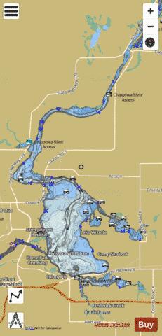
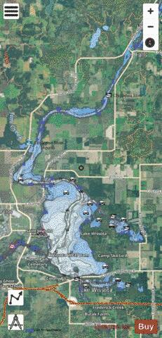
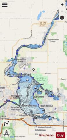
Lake Wissota Fishing Map Stats | |
| Title | Lake Wissota |
| Scale | 1:24000 |
| Counties | Chippewa |
| Nearby Cities | Lake Wissota, Jim Falls, Anson, Eagle Point, Chippewa Falls, Eagleton, Tilden, Hallie, Cadott, Lake Hallie |
| Area * | 6164.57 acres |
| Shoreline * | 59.01 miles |
| Min Longitude | -91.37 |
| Min Latitude | 44.91 |
| Max Longitude | -91.26 |
| Max Latitude | 45.06 |
| Edition Label 1 | |
| Edition Label 2 | |
| Edition Label 3 | |
| Id | US_AA_WI_wissota_lake |
| Country | US |
| Projection | Mercator |
| * some Stats may include nearby/connecting waterbodies | |
|