Squirrel Lake fishing map is available as part of iBoating : USA Marine & Fishing App(now supported on multiple platforms including Android, iPhone/iPad, MacBook, and Windows(tablet and phone)/PC based chartplotter.).
With our Lake Maps App, you get all the great marine chart app features like fishing spots, along with Squirrel Lake depth map. The fishing maps app include HD lake depth contours, along with advanced features found in Fish Finder / Gps Chart Plotter systems, turning your device into a Depth Finder. The Squirrel Lake Navigation App provides advanced features of a Marine Chartplotter including adjusting water level offset and custom depth shading. Fishing spots and depth contours layers are available in most Lake maps. Lake navigation features include advanced instrumentation to gather wind speed direction, water temperature, water depth, and accurate GPS with AIS receivers(using NMEA over TCP/UDP). Autopilot support can be enabled during ‘Goto WayPoint’ and ‘Route Assistance’.
Now i-Boating supports Fishing Points in Squirrel Lake.
Have more questions about the Nautical Chart App? Ask us.
Fishing Info for Squirrel Lake
Squirrel Lake is a 1,309 acres (530 ha) lake in Vilas County and Oneida County, Wisconsin. It has a maximum depth of 46 feet. Several species of fish inhabit the lake and fishing is accessible via a public boat launch. Writer Winifred Dunn spent time during her youth on an island at Squirrel Lake. Minocqua, Wisconsin and the community of Bo-Di-Lac border the lake. The max depth is 46 feet (14 m). A 1918 edition of Field and Stream discussed camping by Squirrel Lake as part of a canoe trips. Water levels in the lake have been managed by Wisconsin Valley Improvement Company (WVIC). The lake has been noted for its water quality and waterfowl. In 1900, Squirrel Lake was included in a surveyor's report.
More on Wikipedia...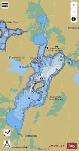
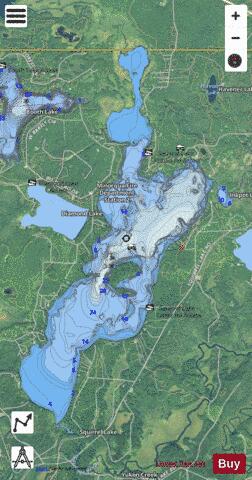
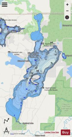
Squirrel Lake Fishing Map Stats | |
| Title | Squirrel Lake |
| Scale | 1:12000 |
| Counties | Oneida, Vilas |
| Nearby Cities | Lac du Flambeau, Minocqua, Hazelhurst, Woodruff, Arbor Vitae, Manitowish Waters, Manitowish, Lake Tomahawk, Tripoli, Harshaw |
| Area * | 1325.43 acres |
| Shoreline * | 14.57 miles |
| Min Longitude | -89.91 |
| Min Latitude | 45.84 |
| Max Longitude | -89.87 |
| Max Latitude | 45.90 |
| Edition Label 1 | |
| Edition Label 2 | |
| Edition Label 3 | |
| Id | US_AA_WI_squirrel_lake_wi |
| Country | US |
| Projection | Mercator |
| * some Stats may include nearby/connecting waterbodies | |
|