Parker Lake Glover fishing map is available as part of iBoating : USA Marine & Fishing App(now supported on multiple platforms including Android, iPhone/iPad, MacBook, and Windows(tablet and phone)/PC based chartplotter.).
With our Lake Maps App, you get all the great marine chart app features like fishing spots, along with Parker Lake Glover depth map. The fishing maps app include HD lake depth contours, along with advanced features found in Fish Finder / Gps Chart Plotter systems, turning your device into a Depth Finder. The Parker Lake Glover Navigation App provides advanced features of a Marine Chartplotter including adjusting water level offset and custom depth shading. Fishing spots and depth contours layers are available in most Lake maps. Lake navigation features include advanced instrumentation to gather wind speed direction, water temperature, water depth, and accurate GPS with AIS receivers(using NMEA over TCP/UDP). Autopilot support can be enabled during ‘Goto WayPoint’ and ‘Route Assistance’.
Now i-Boating supports Fishing Points in Parker Lake Glover.
Have more questions about the Nautical Chart App? Ask us.
Fishing Info for Parker Lake Glover
Lake Parker, is located in the northwest corner of West Glover, Orleans County, Vermont in an area known as the Northeast Kingdom. This freshwater lake covers 239 acres (0.97 km2) and is just over one mile (1.6 km) long and one-half mile wide; its maximum depth is 48 feet (15 m). The lake is fed by two primary streams and outlets into Roaring Brook, which empties into the Barton River, Lake Memphremagog and, eventually, Canada's St. Lawrence River. It is bordered on three sides by seasonal homes; the southern end is a natural estuary sheltering waterfowl. The surrounding land is farmed for raising dairy cattle.
More on Wikipedia...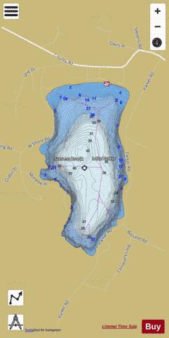
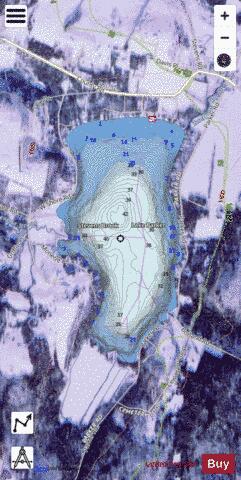
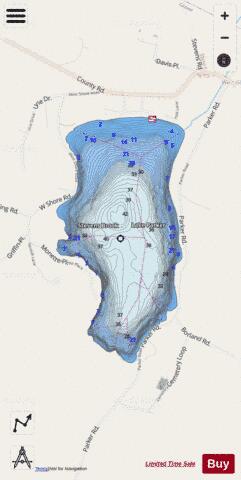
Parker Lake Glover Fishing Map Stats | |
| Title | Parker Lake Glover |
| Scale | 1:3000 |
| Counties | Orleans |
| Nearby Cities | Glover, Barton, Irasburg, Orleans, Albany, Coventry, Greensboro, Craftsbury, Sheffield, Greensboro Bend |
| Area * | 253.16 acres |
| Shoreline * | 3.11 miles |
| Min Longitude | -72.24 |
| Min Latitude | 44.71 |
| Max Longitude | -72.23 |
| Max Latitude | 44.73 |
| Edition Label 1 | |
| Edition Label 2 | |
| Edition Label 3 | |
| Id | US_AA_VT_parker_lake_glover_vt |
| Country | US |
| Projection | Mercator |
| * some Stats may include nearby/connecting waterbodies | |
|