Amistad Reservoir / Lake fishing map is available as part of iBoating : USA Marine & Fishing App(now supported on multiple platforms including Android, iPhone/iPad, MacBook, and Windows(tablet and phone)/PC based chartplotter.).
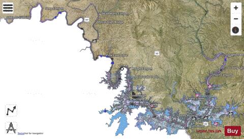
With our Lake Maps App, you get all the great marine chart app features like fishing spots, along with Amistad Reservoir / Lake depth map. The fishing maps app include HD lake depth contours, along with advanced features found in Fish Finder / Gps Chart Plotter systems, turning your device into a Depth Finder. The Amistad Reservoir / Lake Navigation App provides advanced features of a Marine Chartplotter including adjusting water level offset and custom depth shading. Fishing spots and depth contours layers are available in most Lake maps. Lake navigation features include advanced instrumentation to gather wind speed direction, water temperature, water depth, and accurate GPS with AIS receivers(using NMEA over TCP/UDP). Autopilot support can be enabled during ‘Goto WayPoint’ and ‘Route Assistance’.
Now i-Boating supports Fishing Points in Amistad Reservoir / Lake.
Have more questions about the Nautical Chart App? Ask us.
Fishing Info for Amistad Reservoir / Lake
Amistad Reservoir (Spanish: Presa Amistad) is a reservoir on the Rio Grande at its confluence with the Devils River 12 miles (19 km) northwest of Del Rio, Texas. The lake is bounded by Val Verde County on the United States side of the international border and by the state of Coahuila on the Mexican side of the border; the American shoreline forms the Amistad National Recreation Area. The reservoir was formed in 1969 by the construction of Amistad Dam. The dam and lake are managed jointly by the governments of the United States and Mexico through the International Boundary and Water Commission. The name of the dam and lake is the Spanish word for "friendship". The reservoir is also known as Lake Amistad.
More on Wikipedia...Popular fish species in this lake include Amistad gambusia, Largemouth bass and Smallmouth bass.
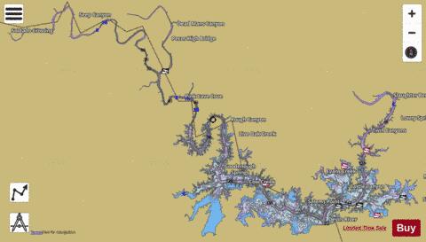
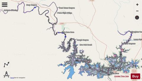
Amistad Reservoir / Lake Fishing Map Stats | |
| Title | Amistad Reservoir / Lake |
| Scale | 1:24000 |
| Counties | Val Verde |
| Nearby Cities | Langtry, Lake View, Comstock, Del Rio, Johnstone, Pumpville, Carta Valley, Malvado, Loma Alta, Pinto |
| Area * | 72579.86 acres |
| Shoreline * | 871.20 miles |
| Min Longitude | -101.66 |
| Min Latitude | 29.43 |
| Max Longitude | -100.88 |
| Max Latitude | 29.81 |
| Edition Label 1 | |
| Edition Label 2 | |
| Edition Label 3 | |
| Id | US_AA_TX_amistad_reservoir_tx |
| Country | US |
| Projection | Mercator |
| * some Stats may include nearby/connecting waterbodies | |
|