Watauga Lake fishing map is available as part of iBoating : USA Marine & Fishing App(now supported on multiple platforms including Android, iPhone/iPad, MacBook, and Windows(tablet and phone)/PC based chartplotter.).
With our Lake Maps App, you get all the great marine chart app features like fishing spots, along with Watauga Lake depth map. The fishing maps app include HD lake depth contours, along with advanced features found in Fish Finder / Gps Chart Plotter systems, turning your device into a Depth Finder. The Watauga Lake Navigation App provides advanced features of a Marine Chartplotter including adjusting water level offset and custom depth shading. Fishing spots and depth contours layers are available in most Lake maps. Lake navigation features include advanced instrumentation to gather wind speed direction, water temperature, water depth, and accurate GPS with AIS receivers(using NMEA over TCP/UDP). Autopilot support can be enabled during ‘Goto WayPoint’ and ‘Route Assistance’.
Now i-Boating supports Fishing Points in Watauga Lake.
Have more questions about the Nautical Chart App? Ask us.
Fishing Info for Watauga Lake
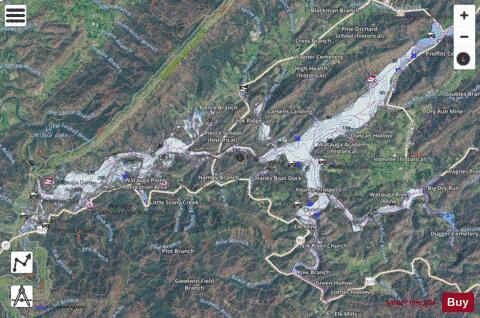
Watauga Lake, located east of Elizabethton, Tennessee, is the local name of the Watauga Reservoir created by the Tennessee Valley Authority (TVA) with the 1948 completion of the TVA Watauga Dam. The Cherokee National Forest surrounds both the Tennessee Valley Authority Watauga Reservoir and Wilbur Reservoir in an area of northeast Tennessee that TVA describes as being located "...in some of the most beautiful country in the Tennessee River watershed."
More on Wikipedia...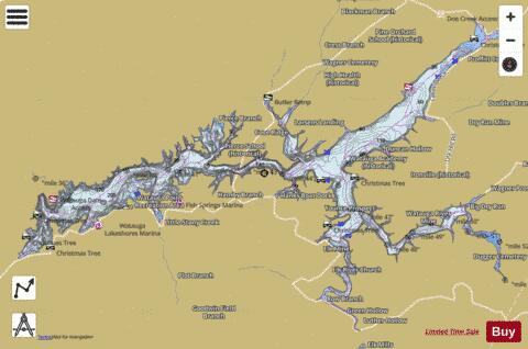
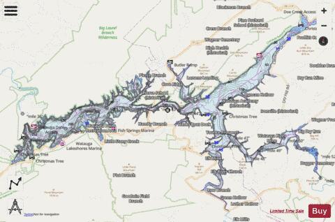
Watauga Lake Fishing Map Stats | |
| Title | Watauga Lake |
| Scale | 1:24000 |
| Counties | Carter, Johnson |
| Nearby Cities | Hampton, Hunter, Carter, Elizabethton, Beech Mountain, Roan Mountain, Elk Park, Banner Elk, Shouns, Sugar Grove |
| Area * | 6353.32 acres |
| Shoreline * | 104.26 miles |
| Min Longitude | -82.13 |
| Min Latitude | 36.28 |
| Max Longitude | -81.93 |
| Max Latitude | 36.38 |
| Edition Label 1 | |
| Edition Label 2 | |
| Edition Label 3 | |
| Id | US_AA_TN_01273873 |
| Country | US |
| Projection | Mercator |
| * some Stats may include nearby/connecting waterbodies | |
|