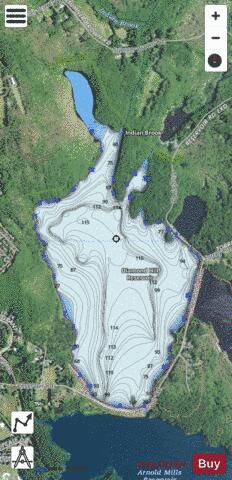
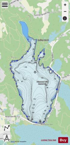
Diamond Hill Reservoir fishing map is available as part of iBoating : USA Marine & Fishing App(now supported on multiple platforms including Android, iPhone/iPad, MacBook, and Windows(tablet and phone)/PC based chartplotter.).
With our Lake Maps App, you get all the great marine chart app features like fishing spots, along with Diamond Hill Reservoir depth map. The fishing maps app include HD lake depth contours, along with advanced features found in Fish Finder / Gps Chart Plotter systems, turning your device into a Depth Finder. The Diamond Hill Reservoir Navigation App provides advanced features of a Marine Chartplotter including adjusting water level offset and custom depth shading. Fishing spots and depth contours layers are available in most Lake maps. Lake navigation features include advanced instrumentation to gather wind speed direction, water temperature, water depth, and accurate GPS with AIS receivers(using NMEA over TCP/UDP). Autopilot support can be enabled during ‘Goto WayPoint’ and ‘Route Assistance’.
Now i-Boating supports Fishing Points in Diamond Hill Reservoir.
Have more questions about the Nautical Chart App? Ask us.
Fishing Info for Diamond Hill Reservoir
Diamond Hill Reservoir (also known as the Pawtucket Upper Reservoir) is a reservoir in Cumberland, Providence County, Rhode Island near Diamond Hill. The earthen Diamond Hill Reservoir Dam was constructed in 1971 with a height of 80 feet, and a length of 2000 feet at its crest. It impounds the Abbott Run waterway for municipal drinking water. Both dam and reservoir are owned and operated by the city of Pawtucket's Water Supply Board. The reservoir it creates has a normal surface area of 390 acres, a maximum capacity of 15,680 acre-feet, and a normal storage of 11,000 acre-feet. Immediately adjacent to the south is the Arnold Mills Reservoir.
More on Wikipedia...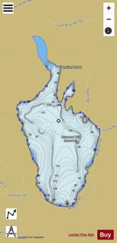
Diamond Hill Reservoir Fishing Map Stats | |
| Title | Diamond Hill Reservoir |
| Scale | 1:12000 |
| Counties | Providence |
| Nearby Cities | Cumberland, Plainville, North Attleborough, Cumberland Hill, Franklin, Manville, Valley Falls, Wrentham, Central Falls, Bellingham |
| Area * | 341.41 acres |
| Shoreline * | 4.75 miles |
| Min Longitude | -71.41 |
| Min Latitude | 41.99 |
| Max Longitude | -71.39 |
| Max Latitude | 42.01 |
| Edition Label 1 | |
| Edition Label 2 | |
| Edition Label 3 | |
| Id | US_AA_RI_diamond_hill_reservoir_ri |
| Country | US |
| Projection | Mercator |
| * some Stats may include nearby/connecting waterbodies | |
|