Walker Lake fishing map is available as part of iBoating : USA Marine & Fishing App(now supported on multiple platforms including Android, iPhone/iPad, MacBook, and Windows(tablet and phone)/PC based chartplotter.).
With our Lake Maps App, you get all the great marine chart app features like fishing spots, along with Walker Lake depth map. The fishing maps app include HD lake depth contours, along with advanced features found in Fish Finder / Gps Chart Plotter systems, turning your device into a Depth Finder. The Walker Lake Navigation App provides advanced features of a Marine Chartplotter including adjusting water level offset and custom depth shading. Fishing spots and depth contours layers are available in most Lake maps. Lake navigation features include advanced instrumentation to gather wind speed direction, water temperature, water depth, and accurate GPS with AIS receivers(using NMEA over TCP/UDP). Autopilot support can be enabled during ‘Goto WayPoint’ and ‘Route Assistance’.
Now i-Boating supports Fishing Points in Walker Lake.
Have more questions about the Nautical Chart App? Ask us.
Fishing Info for Walker Lake
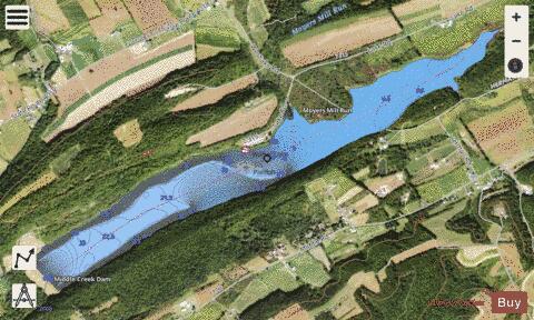
Clarence F. Walker Lake is a 239-acre (0.97 km²) reservoir, formed by a dam and used for flood control and recreation. It is located in Adams Township, Snyder County, Pennsylvania near the town of Troxelville. The lake and shoreline are owned and managed by the Pennsylvania Fish and Boat Commission (PFBC) for recreational fishing and boating.Fish species present include northern pike, largemouth bass, walleye, black crappie, and bluegill. Walker Lake is located on the North Branch Middle Creek, which is a tributary to Middle Creek within the Susquehanna River basin.North Branch Middle Creek was impounded in 1970 creating the 239 acre (0.97 km²) lake, which drains a 19 mi² (49 km²) watershed consisting primarily of forested (57%) and agricultural (39%) areas.Walker Lake has a maximum depth of 32 feet (9.8 m) with a mean depth of 13.8 feet (4.2 m) with an overall volume of 3,317 acre-feet (4,091,000 m3) of water.
More on Wikipedia...Popular fish species in this lake include Black crappie, Largemouth bass, Northern pike and Walleye.
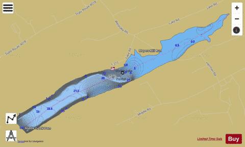
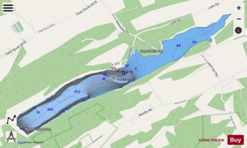
Walker Lake Fishing Map Stats | |
| Title | Walker Lake |
| Scale | 1:1500 |
| Counties | Snyder |
| Nearby Cities | Troxelville, Beavertown, Beaver Springs, Laurelton, Paxtonville, Hartleton, Penns Creek, Middleburg, Richfield, McClure |
| Area * | 229.30 acres |
| Shoreline * | 4.91 miles |
| Min Longitude | -77.20 |
| Min Latitude | 40.80 |
| Max Longitude | -77.16 |
| Max Latitude | 40.81 |
| Edition Label 1 | |
| Edition Label 2 | |
| Edition Label 3 | |
| Id | US_AA_PA_walker_lake_pa |
| Country | US |
| Projection | Mercator |
| * some Stats may include nearby/connecting waterbodies | |
|