Leaser Lake fishing map is available as part of iBoating : USA Marine & Fishing App(now supported on multiple platforms including Android, iPhone/iPad, MacBook, and Windows(tablet and phone)/PC based chartplotter.).
With our Lake Maps App, you get all the great marine chart app features like fishing spots, along with Leaser Lake depth map. The fishing maps app include HD lake depth contours, along with advanced features found in Fish Finder / Gps Chart Plotter systems, turning your device into a Depth Finder. The Leaser Lake Navigation App provides advanced features of a Marine Chartplotter including adjusting water level offset and custom depth shading. Fishing spots and depth contours layers are available in most Lake maps. Lake navigation features include advanced instrumentation to gather wind speed direction, water temperature, water depth, and accurate GPS with AIS receivers(using NMEA over TCP/UDP). Autopilot support can be enabled during ‘Goto WayPoint’ and ‘Route Assistance’.
Now i-Boating supports Fishing Points in Leaser Lake.
Have more questions about the Nautical Chart App? Ask us.
Fishing Info for Leaser Lake
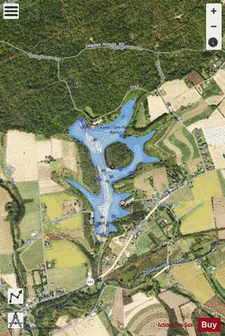
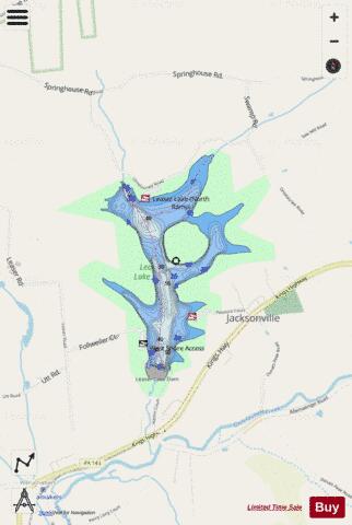
Leaser Lake is a man-made lake located near the village of Jacksonville in Lynn Township, Lehigh County, Pennsylvania. The lake is owned by the Commonwealth and managed by the Pennsylvania Fish and Boat Commission (PFBC). The lake was built for recreational use and opened to the public in 1971. It is the only lake in Lehigh County. The lake is part of a 540 acre park which is owned in part by the PFBC and in part by Lehigh County. The lake covers 117 acres and is 45 feet deep. The lake is created by a dam located on the Jacksonville Branch of the Ontelaunee Creek which is a tributary of Maiden Creek. The dam consists of an earth embankment, approximately 430 feet long by 53 feet high, and the top of the dam is 24 feet wide.
More on Wikipedia...Popular fish species in this lake include Brown bullhead, Largemouth bass, Rainbow trout and Yellow perch.
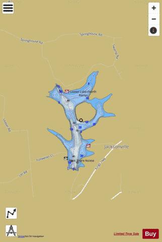
Leaser Lake Fishing Map Stats | |
| Title | Leaser Lake |
| Scale | 1:6000 |
| Counties | Lehigh |
| Nearby Cities | Kempton, New Tripoli, Lenhartsville, Summit Hill, Lansford, New Ringgold, Coaldale, Kutztown, Tamaqua, McKeansburg |
| Area * | 112.02 acres |
| Shoreline * | 4.57 miles |
| Min Longitude | -75.84 |
| Min Latitude | 40.67 |
| Max Longitude | -75.83 |
| Max Latitude | 40.68 |
| Edition Label 1 | |
| Edition Label 2 | |
| Edition Label 3 | |
| Id | US_AA_PA_01217394 |
| Country | US |
| Projection | Mercator |
| * some Stats may include nearby/connecting waterbodies | |
|