Waneta Lake fishing map is available as part of iBoating : USA Marine & Fishing App(now supported on multiple platforms including Android, iPhone/iPad, MacBook, and Windows(tablet and phone)/PC based chartplotter.).
With our Lake Maps App, you get all the great marine chart app features like fishing spots, along with Waneta Lake depth map. The fishing maps app include HD lake depth contours, along with advanced features found in Fish Finder / Gps Chart Plotter systems, turning your device into a Depth Finder. The Waneta Lake Navigation App provides advanced features of a Marine Chartplotter including adjusting water level offset and custom depth shading. Fishing spots and depth contours layers are available in most Lake maps. Lake navigation features include advanced instrumentation to gather wind speed direction, water temperature, water depth, and accurate GPS with AIS receivers(using NMEA over TCP/UDP). Autopilot support can be enabled during ‘Goto WayPoint’ and ‘Route Assistance’.
Now i-Boating supports Fishing Points in Waneta Lake.
Have more questions about the Nautical Chart App? Ask us.
Fishing Info for Waneta Lake
Waneta Lake (previously known as "Little Lake") is a small lake in the Finger Lakes region of the state of New York in the United States. The lake straddles the border of Schuyler County and Steuben County, and is within the towns of Tyrone and Wayne. Waneta Lake is 3.5 miles long (north-to-south) and half a mile wide (east-to-west), and lies just east of the southern branch of Keuka Lake. Despite its location in the Finger Lakes region, it is not counted as one of the eleven Finger Lakes.
More on Wikipedia...Popular fish species in this lake include Black crappie, Brown bullhead, Chain pickerel, Largemouth bass, Rock bass, Smallmouth bass and Yellow perch.
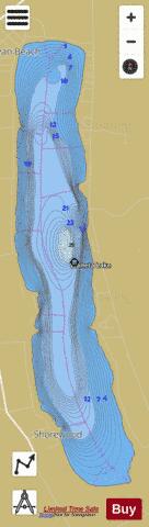


Waneta Lake Fishing Map Stats | |
| Title | Waneta Lake |
| Scale | 1:12000 |
| Counties | Schuyler, Steuben |
| Nearby Cities | Wayne, Keuka, Tyrone, Bradford, Urbana, Pulteney, Barrington, Hammondsport, Dundee, Branchport |
| Area * | 797.22 acres |
| Shoreline * | 6.94 miles |
| Min Longitude | -77.11 |
| Min Latitude | 42.42 |
| Max Longitude | -77.09 |
| Max Latitude | 42.47 |
| Edition Label 1 | |
| Edition Label 2 | |
| Edition Label 3 | |
| Id | US_AA_NY_waneta_lake_ny |
| Country | US |
| Projection | Mercator |
| * some Stats may include nearby/connecting waterbodies | |
|