Black Lake fishing map is available as part of iBoating : USA Marine & Fishing App(now supported on multiple platforms including Android, iPhone/iPad, MacBook, and Windows(tablet and phone)/PC based chartplotter.).
With our Lake Maps App, you get all the great marine chart app features like fishing spots, along with Black Lake depth map. The fishing maps app include HD lake depth contours, along with advanced features found in Fish Finder / Gps Chart Plotter systems, turning your device into a Depth Finder. The Black Lake Navigation App provides advanced features of a Marine Chartplotter including adjusting water level offset and custom depth shading. Fishing spots and depth contours layers are available in most Lake maps. Lake navigation features include advanced instrumentation to gather wind speed direction, water temperature, water depth, and accurate GPS with AIS receivers(using NMEA over TCP/UDP). Autopilot support can be enabled during ‘Goto WayPoint’ and ‘Route Assistance’.
Now i-Boating supports Fishing Points in Black Lake.
Have more questions about the Nautical Chart App? Ask us.
Fishing Info for Black Lake
Black Lake is a lake in the northern part of New York in the United States and is the largest lake in Saint Lawrence County. The lake is south of the Saint Lawrence River and parallels the river for many miles. Black Lake is of glacial origin, having been formed by the melting of continental glaciation in the state around 12,000 years ago. Water flows into the lake from several sources, the largest being the Indian River. The lake drains into the Oswegatchie River and then into the Saint Lawrence River. The northeast end of the lake is south of Ogdensburg, New York. The Mohawk indians referred to the lake as Kanientàrhón:tsi, which translates to "lake is black".
More on Wikipedia...Popular fish species in this lake include Black crappie, Brown bullhead, Largemouth bass, Northern pike, Smallmouth bass, Walleye and Yellow perch.
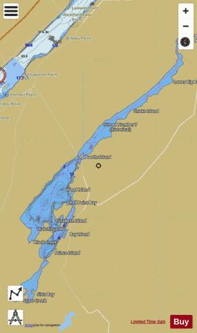
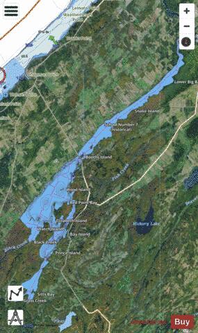
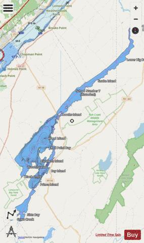
Black Lake Fishing Map Stats | |
| Title | Black Lake |
| This chart covers part of America’s Great Loop | |
| Scale | 1:24000 |
| Counties | St. Lawrence |
| Nearby Cities | Rossie, Hammond, Brier Hill, De Peyster, Heuvelton, Ogdensburg, Morristown, Oxbow, Rensselaer Falls, De Kalb |
| Area * | 7855.96 acres |
| Shoreline * | 74.40 miles |
| Min Longitude | -75.66 |
| Min Latitude | 44.40 |
| Max Longitude | -75.47 |
| Max Latitude | 44.62 |
| Edition Label 1 | |
| Edition Label 2 | |
| Edition Label 3 | |
| Id | US_AA_NY_00977214 |
| Country | US |
| Projection | Mercator |
| * some Stats may include nearby/connecting waterbodies | |
|