Topaz fishing map is available as part of iBoating : USA Marine & Fishing App(now supported on multiple platforms including Android, iPhone/iPad, MacBook, and Windows(tablet and phone)/PC based chartplotter.).
With our Lake Maps App, you get all the great marine chart app features like fishing spots, along with Topaz lake depth map. The fishing maps app include HD lake depth contours, along with advanced features found in Fish Finder / Gps Chart Plotter systems, turning your device into a Depth Finder. The Topaz Navigation App provides advanced features of a Marine Chartplotter including adjusting water level offset and custom depth shading. Fishing spots and depth contours layers are available in most Lake maps. Lake navigation features include advanced instrumentation to gather wind speed direction, water temperature, water depth, and accurate GPS with AIS receivers(using NMEA over TCP/UDP). Autopilot support can be enabled during ‘Goto WayPoint’ and ‘Route Assistance’.
Now i-Boating supports Fishing Points in Topaz.
Have more questions about the Nautical Chart App? Ask us.
Fishing Info for Topaz
Topaz Lake is a reservoir located on the California-Nevada border, about 75 miles (121 km) south of Reno. The census-designated place of Topaz Lake, Nevada, is located along its northwest shore. The modern reservoir was formed by diverting waters from the West Walker River into a nearby basin that had previously contained a smaller, natural lake. That lake had historical significance since it lay on the route taken by American explorer Jedediah Smith in late spring of 1827 when leaving California at the end of his first journey, the first crossing ever of the Sierra Nevada by a non-native. Smith came southeast through Monitor Pass, then east past Topaz Lake into Nevada. The initial dam construction took place in 1922, resulting in a reservoir with a capacity of 45,000 acre-feet (56,000,000 m3). In 1937, a new levee raised the capacity to its current 126,000 acre⋅ft (155,000,000 m3). Topaz Lake is a relatively large reservoir, with a maximum pool of 126,000 acre⋅ft (155,000,000 m3), with 2,410 acres (9.8 km2) surface, a length of 3.5 miles (5.6 km), a width of 1.5 mi (2.4 km), and a maximum depth of 92 ft (28 m). The levee and reservoir have been owned and operated by the Walker River Irrigation District since its construction. Topaz Lake is popular for boaters, water-skiers, campers, and fishermen. Fishing season runs year-round, and the lake is stocked with trout by the Nevada Department of Wildlife and the California Department of Fish and Wildlife. The lake is easily reachable by U.S. Route 395. On the northwest shore of the lake is the Topaz Lodge and a residential area. There is also a volunteer fire station in the area. U.S. Route 395 passes by the west side of the lake at the California-Nevada state line. The southeastern terminus of California State Route 89 is 3 miles (4.8 km) south of the state line. The western terminus of Nevada State Route 208 is 2 mi (3.2 km) north of the state line.
More on Wikipedia...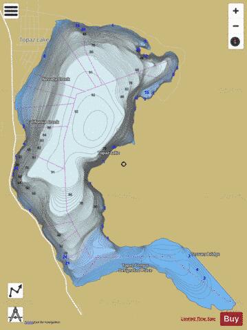
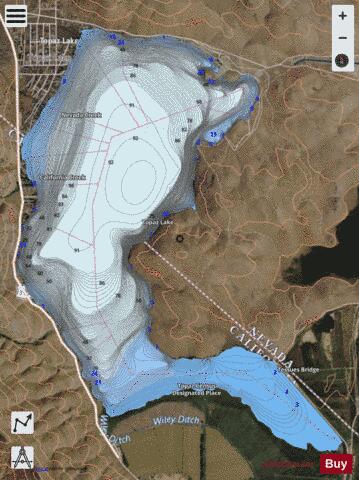
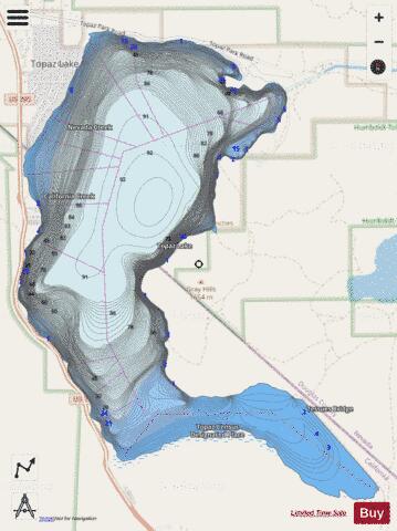
Topaz Fishing Map Stats | |
| Title | Topaz |
| Scale | 1:12000 |
| Counties | Mono, Douglas |
| Nearby Cities | Topaz Lake, Topaz, Holbrook Junction, Topaz Ranch Estates, Coleville, Walker, Wellington, Smith, Markleeville, Woodfords |
| Area * | 2196.58 acres |
| Shoreline * | 12.50 miles |
| Min Longitude | -119.55 |
| Min Latitude | 38.65 |
| Max Longitude | -119.50 |
| Max Latitude | 38.70 |
| Edition Label 1 | |
| Edition Label 2 | |
| Edition Label 3 | |
| Id | US_AA_NV_topaz_nv |
| Country | US |
| Projection | Mercator |
| * some Stats may include nearby/connecting waterbodies | |
|