Rye Patch Reservoir + Lassens Meadows + Pitt-Taylor fishing map is available as part of iBoating : USA Marine & Fishing App(now supported on multiple platforms including Android, iPhone/iPad, MacBook, and Windows(tablet and phone)/PC based chartplotter.).
With our Lake Maps App, you get all the great marine chart app features like fishing spots, along with Rye Patch Reservoir + Lassens Meadows + Pitt-Taylor depth map. The fishing maps app include HD lake depth contours, along with advanced features found in Fish Finder / Gps Chart Plotter systems, turning your device into a Depth Finder. The Rye Patch Reservoir + Lassens Meadows + Pitt-Taylor Navigation App provides advanced features of a Marine Chartplotter including adjusting water level offset and custom depth shading. Fishing spots and depth contours layers are available in most Lake maps. Lake navigation features include advanced instrumentation to gather wind speed direction, water temperature, water depth, and accurate GPS with AIS receivers(using NMEA over TCP/UDP). Autopilot support can be enabled during ‘Goto WayPoint’ and ‘Route Assistance’.
Now i-Boating supports Fishing Points in Rye Patch Reservoir + Lassens Meadows + Pitt-Taylor.
Have more questions about the Nautical Chart App? Ask us.
Fishing Info for Rye Patch Reservoir + Lassens Meadows + Pitt-Taylor
The Rye Patch Reservoir is a reservoir on the Humboldt River in the U.S. State of Nevada. It is located about 22 miles northeast of the town of Lovelock, and is managed by the Pershing County Water Conservation District. The reservoir stores water for the agricultural area surrounding Lovelock, which is at the far downstream reach of the Humboldt, near the Humboldt Sink. Since the Lovelock area receives a mere 5.76 inches of rain annually, agriculture requires irrigation, but the high variability of the Humboldt (which often runs completely dry) means that water storage is necessary for irrigation to be feasible.
More on Wikipedia...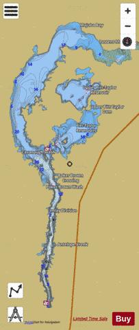
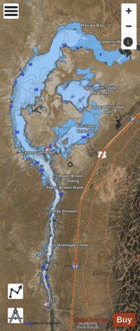
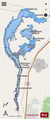
Rye Patch Reservoir + Lassens Meadows + Pitt-Taylor Fishing Map Stats | |
| Title | Rye Patch Reservoir + Lassens Meadows + Pitt-Taylor |
| Scale | 1:12000 |
| Counties | Pershing |
| Nearby Cities | Humboldt, Humboldt River Ranch, Imlay, Oreana, Mill City, Unionville, Woolsey, Jungo, Cosgrave, Pronto |
| Area * | 16036.27 acres |
| Shoreline * | 163.53 miles |
| Min Longitude | -118.35 |
| Min Latitude | 40.47 |
| Max Longitude | -118.22 |
| Max Latitude | 40.71 |
| Edition Label 1 | |
| Edition Label 2 | |
| Edition Label 3 | |
| Id | US_AA_NV_rye_patch_reservoir_nv |
| Country | US |
| Projection | Mercator |
| * some Stats may include nearby/connecting waterbodies | |
|