Washoe Lake fishing map is available as part of iBoating : USA Marine & Fishing App(now supported on multiple platforms including Android, iPhone/iPad, MacBook, and Windows(tablet and phone)/PC based chartplotter.).
With our Lake Maps App, you get all the great marine chart app features like fishing spots, along with Washoe Lake depth map. The fishing maps app include HD lake depth contours, along with advanced features found in Fish Finder / Gps Chart Plotter systems, turning your device into a Depth Finder. The Washoe Lake Navigation App provides advanced features of a Marine Chartplotter including adjusting water level offset and custom depth shading. Fishing spots and depth contours layers are available in most Lake maps. Lake navigation features include advanced instrumentation to gather wind speed direction, water temperature, water depth, and accurate GPS with AIS receivers(using NMEA over TCP/UDP). Autopilot support can be enabled during ‘Goto WayPoint’ and ‘Route Assistance’.
Now i-Boating supports Fishing Points in Washoe Lake.
Have more questions about the Nautical Chart App? Ask us.
Fishing Info for Washoe Lake
Washoe Lake (Washo: c'óʔyaʔ dáʔaw ) is a lake located near Carson City in the Washoe Valley of Washoe County, Nevada. It is a very shallow lake with a surface area that can vary greatly from year to year. Washoe Lake State Park sits on the lake's southeastern shore. Washoe Lake is a eutrophic, shallow lake between Reno and Carson City and just east of the much larger Lake Tahoe. The lake reaches a maximum depth of just 12 feet (3.7 m). The shallowness and the high winds make the lake very turbid. Extensive droughts in the past have caused the lake to dry up entirely, most recently in 1992, 1994, and 2004. Washoe Lake is a warm water fishery and provides a habitat for non-native Sacramento perch, white bass, channel catfish, brown bullhead and carp. The lake has been stocked by the Nevada Division of Wildlife since 2004 when Washoe Lake last dried up. Two boat launches are on the eastern shore of the lake within Washoe Lake State Park. The lake provides habitat for a variety of birds. There are hundreds of migratory and resident species in Washoe Lake State Park. Pelicans, night and great blue herons can be found on the waters of the lake.
More on Wikipedia...Popular fish species in this lake include Brown bullhead, Sacramento perch and White bass.
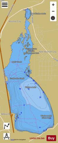
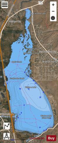
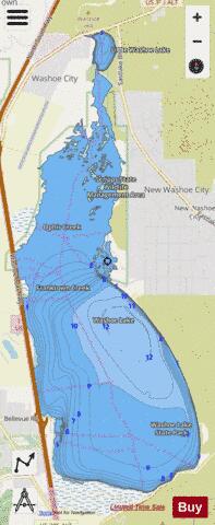
Washoe Lake Fishing Map Stats | |
| Title | Washoe Lake |
| Scale | 1:24000 |
| Counties | Washoe |
| Nearby Cities | Washoe City, New Washoe City, Carson City, Virginia City, Incline Village, Dayton, Crystal Bay, Glenbrook, Reno, Sparks |
| Area * | 5566.65 acres |
| Shoreline * | 40.52 miles |
| Min Longitude | -119.82 |
| Min Latitude | 39.23 |
| Max Longitude | -119.77 |
| Max Latitude | 39.33 |
| Edition Label 1 | |
| Edition Label 2 | |
| Edition Label 3 | |
| Id | US_AA_NV_00861907 |
| Country | US |
| Projection | Mercator |
| * some Stats may include nearby/connecting waterbodies | |
|