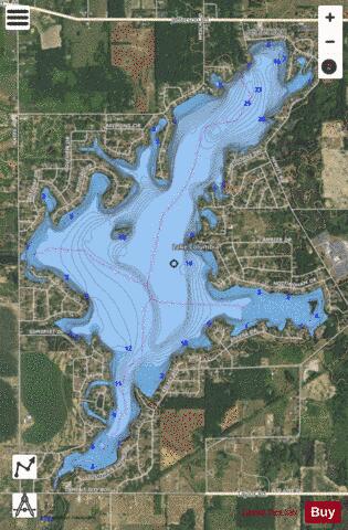
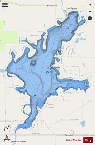
Columbia Lake fishing map is available as part of iBoating : USA Marine & Fishing App(now supported on multiple platforms including Android, iPhone/iPad, MacBook, and Windows(tablet and phone)/PC based chartplotter.).
With our Lake Maps App, you get all the great marine chart app features like fishing spots, along with Columbia Lake depth map. The fishing maps app include HD lake depth contours, along with advanced features found in Fish Finder / Gps Chart Plotter systems, turning your device into a Depth Finder. The Columbia Lake Navigation App provides advanced features of a Marine Chartplotter including adjusting water level offset and custom depth shading. Fishing spots and depth contours layers are available in most Lake maps. Lake navigation features include advanced instrumentation to gather wind speed direction, water temperature, water depth, and accurate GPS with AIS receivers(using NMEA over TCP/UDP). Autopilot support can be enabled during ‘Goto WayPoint’ and ‘Route Assistance’.
Now i-Boating supports Fishing Points in Columbia Lake.
Have more questions about the Nautical Chart App? Ask us.
Fishing Info for Columbia Lake
Lake Columbia is a man-made lake in Columbia Township in southern Jackson County in the U.S. state of Michigan. Originally formed as a mill pond in 1836, it was expanded to 840 acres (3.4 km2) in 1961. At its greatest extent, the lake is 2 and 1/4 miles long and 1 and 3/4 miles wide. It has approximately 14 miles (23 km) of shoreline and the water source to the lake is Goose Creek. The lake has an average depth of 18 feet (5.5 m). Lake Columbia is located 2 miles (3.2 km) west of Brooklyn, Michigan. The latitude for the lake is 42.0928 and the longitude is -84.3011 with an elevation of 988 ft (301 m) above sea level. Lake Columbia is one of the many lakes in Jackson County that is entirely private. Yearly membership dues in the Lake Columbia Property Owners Association are required by residents of the lake. The lake has a total of 16 private parks. It also has 14 named shores where residents reside. It is a boaters and fishers paradise for local residents of the lake. Lake Columbia is stocked annually with Walleye or Bluegill fish. The fish population continues to grow in Lake Columbia every year.
More on Wikipedia...Popular fish species in this lake include Walleye.
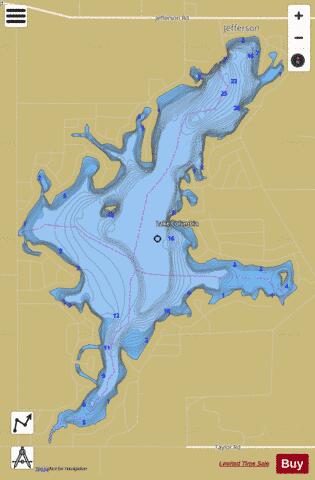
Columbia Lake Fishing Map Stats | |
| Title | Columbia Lake |
| Scale | 1:12000 |
| Includes Data from Fish Atlas | Yes |
| Counties | Jackson |
| Nearby Cities | Cement City, Brooklyn, Clarklake, Napoleon, Devils Lake, Addison, Manitou Beach, Onsted, Vandercook Lake, Michigan Center |
| Area * | 816.94 acres |
| Shoreline * | 14.60 miles |
| Min Longitude | -84.32 |
| Min Latitude | 42.07 |
| Max Longitude | -84.28 |
| Max Latitude | 42.11 |
| Edition Label 1 | |
| Edition Label 2 | |
| Edition Label 3 | |
| Id | US_AA_MI_columbia_lake_a_mi |
| Country | US |
| Projection | Mercator |
| * some Stats may include nearby/connecting waterbodies | |
|