Lake Needwood fishing map is available as part of iBoating : USA Marine & Fishing App(now supported on multiple platforms including Android, iPhone/iPad, MacBook, and Windows(tablet and phone)/PC based chartplotter.).
With our Lake Maps App, you get all the great marine chart app features like fishing spots, along with Lake Needwood depth map. The fishing maps app include HD lake depth contours, along with advanced features found in Fish Finder / Gps Chart Plotter systems, turning your device into a Depth Finder. The Lake Needwood Navigation App provides advanced features of a Marine Chartplotter including adjusting water level offset and custom depth shading. Fishing spots and depth contours layers are available in most Lake maps. Lake navigation features include advanced instrumentation to gather wind speed direction, water temperature, water depth, and accurate GPS with AIS receivers(using NMEA over TCP/UDP). Autopilot support can be enabled during ‘Goto WayPoint’ and ‘Route Assistance’.
Now i-Boating supports Fishing Points in Lake Needwood.
Have more questions about the Nautical Chart App? Ask us.
Fishing Info for Lake Needwood
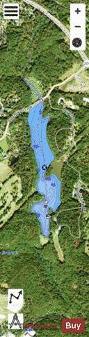
Lake Needwood is a 75-acre (300,000 m2) reservoir in Derwood, Maryland, United States. Located east of Rockville, in the eastern part of Montgomery County, it is situated on Rock Creek. The lake was created by damming Rock Creek in 1965 with the goal of providing flood control and reducing soil erosion. Lake Needwood also protects the water quality of the creek by functioning as a retention basin to trap sediment from storm-water runoff. The lake is part of Rock Creek Regional Park. Visitors can rent pedal boats, rowboats, and canoes, and a flat-bottom pontoon boat, the Needwood Queen, is available for rides. Also, the picnic areas surrounding the lake are popular locations for various events. Other park features include a visitors center and snack bar, hiking and biking trails, playgrounds, an archery range and Needwood Golf Course. About one mile (1.6 km) southeast is Lake Needwood's sister lake, Lake Frank. The Rock Creek Trail begins at Lake Needwood and can be followed along the course of Rock Creek, ending at the Potomac River in Washington, D.C.
More on Wikipedia...Popular fish species in this lake include Crappie and Largemouth bass.
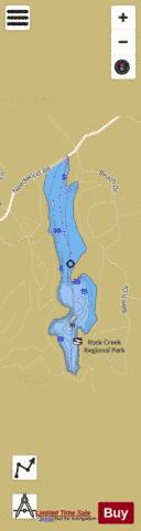
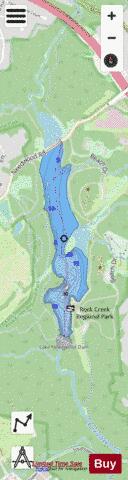
Lake Needwood Fishing Map Stats | |
| Title | Lake Needwood |
| Scale | 1:6000 |
| Counties | Montgomery |
| Nearby Cities | Redland, Derwood, Rockville, Washington Grove, Norbeck, Rossmoor, Aspen Hill, Olney, Gaithersburg, Montgomery Village |
| Area * | 61.58 acres |
| Shoreline * | 2.42 miles |
| Min Longitude | -77.13 |
| Min Latitude | 39.11 |
| Max Longitude | -77.13 |
| Max Latitude | 39.13 |
| Edition Label 1 | |
| Edition Label 2 | |
| Edition Label 3 | |
| Id | US_AA_MD_lakeneedwood |
| Country | US |
| Projection | Mercator |
| * some Stats may include nearby/connecting waterbodies | |
|