Lake Shafer fishing map is available as part of iBoating : USA Marine & Fishing App(now supported on multiple platforms including Android, iPhone/iPad, MacBook, and Windows(tablet and phone)/PC based chartplotter.).
With our Lake Maps App, you get all the great marine chart app features like fishing spots, along with Lake Shafer depth map. The fishing maps app include HD lake depth contours, along with advanced features found in Fish Finder / Gps Chart Plotter systems, turning your device into a Depth Finder. The Lake Shafer Navigation App provides advanced features of a Marine Chartplotter including adjusting water level offset and custom depth shading. Fishing spots and depth contours layers are available in most Lake maps. Lake navigation features include advanced instrumentation to gather wind speed direction, water temperature, water depth, and accurate GPS with AIS receivers(using NMEA over TCP/UDP). Autopilot support can be enabled during ‘Goto WayPoint’ and ‘Route Assistance’.
Now i-Boating supports Fishing Points in Lake Shafer.
Have more questions about the Nautical Chart App? Ask us.
Fishing Info for Lake Shafer
Lake Shafer is one of two reservoirs located in the Twin Lakes area of Monticello, Indiana. It was created along with Lake Freeman in the 1920s when two dams were built outside of Monticello on the Tippecanoe River. It remains a popular recreational area and helps generate an estimated $70 million in tourism revenue for White County.
More on Wikipedia...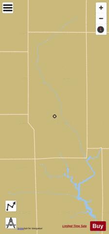
Lake Shafer Fishing Map Stats | |
| Title | Lake Shafer |
| Scale | 1:3000 |
| Counties | Pulaski, White |
| Nearby Cities | Buffalo, Norway, Monon, Francesville, Monticello, Medaryville, Reynolds, Lee, Denham, Idaville |
| Area * | 1451.67 acres |
| Shoreline * | 115.92 miles |
| Min Longitude | -86.93 |
| Min Latitude | 40.78 |
| Max Longitude | -86.75 |
| Max Latitude | 41.08 |
| Edition Label 1 | |
| Edition Label 2 | |
| Edition Label 3 | |
| Id | US_AA_IN_lake_shafer__in |
| Country | US |
| Projection | Mercator |
| * some Stats may include nearby/connecting waterbodies | |
|