Lake Iliamna fishing map is available as part of iBoating : USA Marine & Fishing App(now supported on multiple platforms including Android, iPhone/iPad, MacBook, and Windows(tablet and phone)/PC based chartplotter.).
With our Lake Maps App, you get all the great marine chart app features like fishing spots, along with Lake Iliamna depth map. The fishing maps app include HD lake depth contours, along with advanced features found in Fish Finder / Gps Chart Plotter systems, turning your device into a Depth Finder. The Lake Iliamna Navigation App provides advanced features of a Marine Chartplotter including adjusting water level offset and custom depth shading. Fishing spots and depth contours layers are available in most Lake maps. Lake navigation features include advanced instrumentation to gather wind speed direction, water temperature, water depth, and accurate GPS with AIS receivers(using NMEA over TCP/UDP). Autopilot support can be enabled during ‘Goto WayPoint’ and ‘Route Assistance’.
Now i-Boating supports Fishing Points in Lake Iliamna.
Have more questions about the Nautical Chart App? Ask us.
Fishing Info for Lake Iliamna
Iliamna Lake or Lake Iliamna (Yup'ik: Nanvarpak; Dena'ina Athabascan: Nila Vena) is a lake in southwest Alaska, at the north end of the Alaska Peninsula, between Kvichak Bay and Cook Inlet, about 100 miles (160 km) west of Seldovia, Alaska. It is the largest lake in Alaska, 3rd largest lake entirely in the United States, and twenty-fourth in North America. Covering about 2,600 km2 (1,000 sq mi), Iliamna Lake is 77 miles (124 km) long and up to 22 miles (35 km) wide, with a maximum depth of 988 feet (301 m). Through the Kvichak River, its waters drain into Bristol Bay.
More on Wikipedia...Popular fish species in this lake include Pacific sleeper shark, Rainbow trout and White sturgeon.

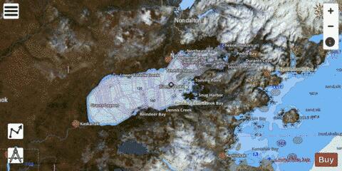
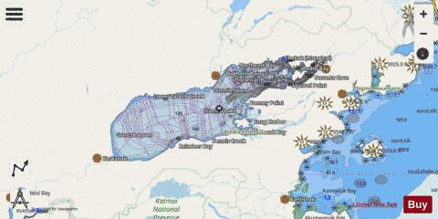
Lake Iliamna Fishing Map Stats | |
| Title | Lake Iliamna |
| Scale | 1:12000 |
| Counties | Lake and Peninsula |
| Nearby Cities | Pedro Bay, Kokhanok, Igiugig, Newhalen, Iliamna, Nondalton, Port Alsworth, Levelock |
| Area * | 643982.49 acres |
| Shoreline * | 572.72 miles |
| Min Longitude | -155.92 |
| Min Latitude | 59.31 |
| Max Longitude | -153.87 |
| Max Latitude | 59.81 |
| Edition Label 1 | |
| Edition Label 2 | |
| Edition Label 3 | |
| Id | US_AA_AK_lake_iliamna_ak |
| Country | US |
| Projection | Mercator |
| * some Stats may include nearby/connecting waterbodies | |
|