Altoona Lake fishing map is available as part of iBoating : USA Marine & Fishing App(now supported on multiple platforms including Android, iPhone/iPad, MacBook, and Windows(tablet and phone)/PC based chartplotter.).
With our Lake Maps App, you get all the great marine chart app features like fishing spots, along with Altoona Lake depth map. The fishing maps app include HD lake depth contours, along with advanced features found in Fish Finder / Gps Chart Plotter systems, turning your device into a Depth Finder. The Altoona Lake Navigation App provides advanced features of a Marine Chartplotter including adjusting water level offset and custom depth shading. Fishing spots and depth contours layers are available in most Lake maps. Lake navigation features include advanced instrumentation to gather wind speed direction, water temperature, water depth, and accurate GPS with AIS receivers(using NMEA over TCP/UDP). Autopilot support can be enabled during ‘Goto WayPoint’ and ‘Route Assistance’.
Now i-Boating supports Fishing Points in Altoona Lake.
Have more questions about the Nautical Chart App? Ask us.
Fishing Info for Altoona Lake
Lake Altoona, is a man-made lake in Eau Claire County, Wisconsin, United States, bordering the city of Altoona, Wisconsin, and to the east of Eau Claire. The lake was created by impounding the Eau Claire River with the construction of the Altoona 2WP340 Dam in 1938, with a concrete spillway and sluice gates on the western end of the reservoir. (The "2WP340" refers to the permit number of the Public Service Commission of Wisconsin authorizing the dam.) The dam is owned and operated by Eau Claire County for recreation and water conservation. No hydroelectric power is generated. The lake has a surface area of 840 ares (900,000 sq ft), and is adjacent to Lake Altoona County Park with various recreational facilities. Altoona Lake is a 720 acre lake located in Eau Claire County. It has a maximum depth of 25 feet.
More on Wikipedia...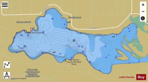
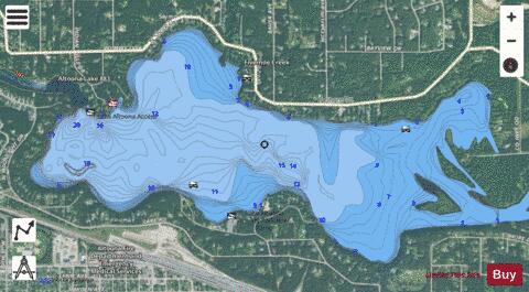
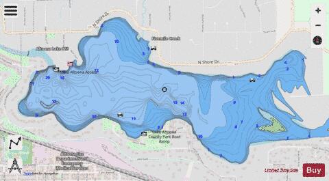
Altoona Lake Fishing Map Stats | |
| Title | Altoona Lake |
| Scale | 1:6000 |
| Counties | Eau Claire |
| Nearby Cities | Seymour, Altoona, Eau Claire, Lake Hallie, Hallie, Chippewa Falls, Brackett, Fall Creek, Lake Wissota, Howard |
| Area * | 720.22 acres |
| Shoreline * | 8.87 miles |
| Min Longitude | -91.45 |
| Min Latitude | 44.81 |
| Max Longitude | -91.40 |
| Max Latitude | 44.82 |
| Edition Label 1 | |
| Edition Label 2 | |
| Edition Label 3 | |
| Id | US_WI_altoona_lake |
| Country | US |
| Projection | Mercator |
| * some Stats may include nearby/connecting waterbodies | |
|