Curlew Lake fishing map is available as part of iBoating : USA Marine & Fishing App(now supported on multiple platforms including Android, iPhone/iPad, MacBook, and Windows(tablet and phone)/PC based chartplotter.).
With our Lake Maps App, you get all the great marine chart app features like fishing spots, along with Curlew Lake depth map. The fishing maps app include HD lake depth contours, along with advanced features found in Fish Finder / Gps Chart Plotter systems, turning your device into a Depth Finder. The Curlew Lake Navigation App provides advanced features of a Marine Chartplotter including adjusting water level offset and custom depth shading. Fishing spots and depth contours layers are available in most Lake maps. Lake navigation features include advanced instrumentation to gather wind speed direction, water temperature, water depth, and accurate GPS with AIS receivers(using NMEA over TCP/UDP). Autopilot support can be enabled during ‘Goto WayPoint’ and ‘Route Assistance’.
Now i-Boating supports Fishing Points in Curlew Lake.
Have more questions about the Nautical Chart App? Ask us.
Fishing Info for Curlew Lake
Curlew Lake is a 921-acre (3.73 km2) lake located in the glacier-carved Curlew Valley northeast of Republic, Washington. The spring- and stream-fed lake is named for the long-billed curlew, Numenius americanus, that once frequented the area. The 7-mile-long (11 km) lake reaches a maximum of 1⁄3 miles wide and includes four small islands. The average depth of the lake is 43 ft (13 m) deep with a maximum depth of 130 ft (40 m) reached in the northern area. Curlew Lake provides visitors and residents with opportunities for kayaking, boating, fishing, swimming, water skiing, canoeing, and sailing. Public access is available at Curlew Lake State Park at the lake's south end. The first elevation determinations for Ferry County establishing the water level of Curlew Lake were made from 1901 to 1903 by E. M. Fry and F.E. Fellows. The official elevation of the surface of Curlew Lake was recorded on May 13, 1901, as 2,345 ft (715 m). In 1917 the Washington State legislature granted the Curlew Irrigation District the right to overflow the shore lands bordering the lake up to and including the high-water mark. Two years later a recommendation was made by the state game warden in 1919 that Curlew Lake be made into a reservoir for storing irrigation water. In 1926, with the construction of a 3 ft (0.91 m) dam at the north end of the lake, the water level was stabilized at an elevation 2,333 ft (711 m), 12 ft (3.7 m) lower than the original 1901 determination. The lake hosts a number of native and introduced fish including Salvelinus fontinalis (brook trout), Salmo trutta (brown trout), Micropterus salmoides (largemouth bass), Oncorhynchus mykiss (rainbow trout), Esox masquinongy X Esox lucius (tiger muskellunge), and Ptychocheilus oregonensis (squawfish). The tiger muskellunge, raised at the in Moses Lake, were initially released into the lake in 1997 to control populations of squawfish. Several of the native mollusks found in the lake are now listed as species of concern. Anodonta californiensis commonly called the California floater is a species of mussel which was formerly found throughout Washington and in disjunct populations across the Western United States. The current Washington range is limited to Curlew Lake and three other locations. The severe reduction in range has resulted in the species' listing as a federal and state species of concern. The masked duskysnail (Lyogyrus) and Washington duskysnail (Amnicola), both undescribed species, are found in only two glacial kettle lakes in Washington, Fish Lake in Okanogan County and Curlew Lake. Believed to have formerly ranged in glacial lakes from the Cascades to the Rockies, the Washington duskysnail is now only found in one location outside of Washington, and both snails are limited to the two lakes in Washington. This isolated range has placed them on state and federal watchlists as critically imperiled species. Curlew Lake is one of several lakes in Eastern Washington to host a population of Euhrychiopsis lecontei (milfoil weevil) subsisting on the native milfoil species Myriophyllum sibiricum (northern milfoil).
More on Wikipedia...Popular fish species in this lake include Rainbow trout.
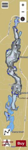
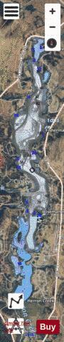
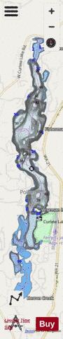
Curlew Lake Fishing Map Stats | |
| Title | Curlew Lake |
| Scale | 1:12000 |
| Counties | Ferry |
| Nearby Cities | Torboy, Malo, Republic, Curlew, Aeneas, Chesaw, Orient, Laurier, Barstow, Boyds |
| Area * | 884.19 acres |
| Shoreline * | 16.33 miles |
| Min Longitude | -118.67 |
| Min Latitude | 48.70 |
| Max Longitude | -118.66 |
| Max Latitude | 48.77 |
| Edition Label 1 | |
| Edition Label 2 | |
| Edition Label 3 | |
| Id | US_WA_01518419 |
| Country | US |
| Projection | Mercator |
| * some Stats may include nearby/connecting waterbodies | |
|