Black Lake fishing map is available as part of iBoating : USA Marine & Fishing App(now supported on multiple platforms including Android, iPhone/iPad, MacBook, and Windows(tablet and phone)/PC based chartplotter.).
With our Lake Maps App, you get all the great marine chart app features like fishing spots, along with Black Lake depth map. The fishing maps app include HD lake depth contours, along with advanced features found in Fish Finder / Gps Chart Plotter systems, turning your device into a Depth Finder. The Black Lake Navigation App provides advanced features of a Marine Chartplotter including adjusting water level offset and custom depth shading. Fishing spots and depth contours layers are available in most Lake maps. Lake navigation features include advanced instrumentation to gather wind speed direction, water temperature, water depth, and accurate GPS with AIS receivers(using NMEA over TCP/UDP). Autopilot support can be enabled during ‘Goto WayPoint’ and ‘Route Assistance’.
Now i-Boating supports Fishing Points in Black Lake.
Have more questions about the Nautical Chart App? Ask us.
Fishing Info for Black Lake
Black Lake is a lake located about 4 miles (6.4 km) southwest of Olympia, Washington. It has two outflows; the Black River, which drains into the Chehalis River and thence to Gray's Harbor and the Pacific Ocean, and Percival Creek, which drains into Capitol Lake and thence into Puget Sound. Black Lake was so named on account of the dark character of its water.
More on Wikipedia...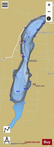
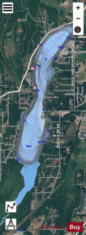
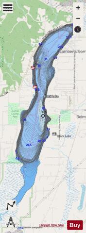
Black Lake Fishing Map Stats | |
| Title | Black Lake |
| Scale | 1:12000 |
| Counties | Thurston |
| Nearby Cities | Tumwater, Littlerock, Olympia, East Olympia, Lacey, Boston Harbor, Tenino, Grand Mound, Rochester, Thompson Place |
| Area * | 658.41 acres |
| Shoreline * | 7.75 miles |
| Min Longitude | -122.99 |
| Min Latitude | 46.96 |
| Max Longitude | -122.96 |
| Max Latitude | 47.01 |
| Edition Label 1 | |
| Edition Label 2 | |
| Edition Label 3 | |
| Id | US_WA_01503407 |
| Country | US |
| Projection | Mercator |
| * some Stats may include nearby/connecting waterbodies | |
|