Little Cedar Lake fishing map is available as part of iBoating : USA Marine & Fishing App(now supported on multiple platforms including Android, iPhone/iPad, MacBook, and Windows(tablet and phone)/PC based chartplotter.).
With our Lake Maps App, you get all the great marine chart app features like fishing spots, along with Little Cedar Lake depth map. The fishing maps app include HD lake depth contours, along with advanced features found in Fish Finder / Gps Chart Plotter systems, turning your device into a Depth Finder. The Little Cedar Lake Navigation App provides advanced features of a Marine Chartplotter including adjusting water level offset and custom depth shading. Fishing spots and depth contours layers are available in most Lake maps. Lake navigation features include advanced instrumentation to gather wind speed direction, water temperature, water depth, and accurate GPS with AIS receivers(using NMEA over TCP/UDP). Autopilot support can be enabled during ‘Goto WayPoint’ and ‘Route Assistance’.
Now i-Boating supports Fishing Points in Little Cedar Lake.
Have more questions about the Nautical Chart App? Ask us.
Fishing Info for Little Cedar Lake
Little Cedar Lake is a lake in Southeastern Wisconsin; United States. It is located at the geographic center of Washington County, in the Town of West Bend, and Town of Polk. The lake covers an area of 246 acres (1 km2), has a shoreline of 4.5 miles (7 km), and reaches a maximum depth of 56 feet (17 m). Its source is Cedar Creek which flows into the northwest side of the lake, and its outflow is Cedar Creek, which continues to flow south at the bottom a small dam at the extreme southern tip of the lake. Spring, summer and autumn activities on the lake include boating, fishing, and water skiing. In winter the lake freezes over completely with ice up to 36 inches thick, Winter activities on the lake include ice fishing and snowmobiling. Many species of fish are found in Little Cedar Lake, including northern pike, walleye, rock bass, smallmouth bass, bluegills, carp, and bullheads. The Lake is located approximately 30 mi (48 km) NNW of Milwaukee, and 5 mi (8.0 km) SW of the City of West Bend. * Fall Colors Reflecting on the Lake * Reflecting Sun * Summer Recreation * Independence Day Boat Parade * Best Parade Boat * Frozen lake
More on Wikipedia...Popular fish species in this lake include Ameiurus, Northern pike, Rock bass, Smallmouth bass and Walleye.
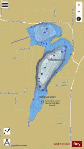
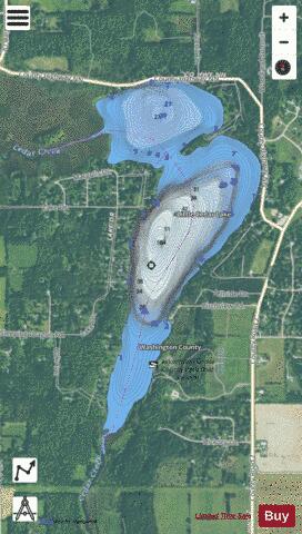
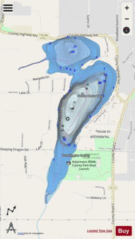
Little Cedar Lake Fishing Map Stats | |
| Title | Little Cedar Lake |
| Scale | 1:6000 |
| Counties | Washington |
| Nearby Cities | West Bend, Slinger, Barton, Jackson, Allenton, Richfield, Kewaskum, Addison, Rockfield, Hartford |
| Area * | 260.25 acres |
| Shoreline * | 4.94 miles |
| Min Longitude | -88.24 |
| Min Latitude | 43.36 |
| Max Longitude | -88.22 |
| Max Latitude | 43.38 |
| Edition Label 1 | |
| Edition Label 2 | |
| Edition Label 3 | |
| Id | US_UB_WI_01568222 |
| Country | US |
| Projection | Mercator |
| * some Stats may include nearby/connecting waterbodies | |
|