Lake Koshkonong fishing map is available as part of iBoating : USA Marine & Fishing App(now supported on multiple platforms including Android, iPhone/iPad, MacBook, and Windows(tablet and phone)/PC based chartplotter.).
With our Lake Maps App, you get all the great marine chart app features like fishing spots, along with Lake Koshkonong depth map. The fishing maps app include HD lake depth contours, along with advanced features found in Fish Finder / Gps Chart Plotter systems, turning your device into a Depth Finder. The Lake Koshkonong Navigation App provides advanced features of a Marine Chartplotter including adjusting water level offset and custom depth shading. Fishing spots and depth contours layers are available in most Lake maps. Lake navigation features include advanced instrumentation to gather wind speed direction, water temperature, water depth, and accurate GPS with AIS receivers(using NMEA over TCP/UDP). Autopilot support can be enabled during ‘Goto WayPoint’ and ‘Route Assistance’.
Now i-Boating supports Fishing Points in Lake Koshkonong.
Have more questions about the Nautical Chart App? Ask us.
Fishing Info for Lake Koshkonong
Lake Koshkonong is naturally occurring lake that acts as a reservoir in southern Wisconsin. Its size was augmented by the creation of the Indianford Dam in 1932, making it one of the larger lakes in the state. The lake lies along the Rock River, with the river acting as both the primary inflow and the primary outflow for the lake. Lake Koshkonong begins 5.5 mi (8.9 km) downriver from Fort Atkinson, with the large majority of the lake located in southwestern Jefferson County. Small portions of the lake extend into southeastern Dane and northern Rock counties. After the creation of the Indianford Dam, which was built several miles down the Rock River from Lake Koshkonong, the lake has had a surface area measuring 10,460 acres (42.3 km2). It remains very shallow with an average depth of six feet (1.8 meters) and a maximum depth of seven feet (2.1 meters). The dam itself measures 13 feet (4.0 meters) high and with a length of 500 ft (150 m) at its crest. Maximum capacity of the reservoir is 107,000 acre⋅ft (132,000,000 m3). Both dam and reservoir are owned and operated by Rock County.
More on Wikipedia...Popular fish species in this lake include Largemouth bass, Northern pike, Paddlefish, Panfish, Smallmouth bass and Walleye.
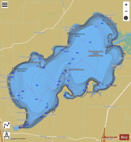
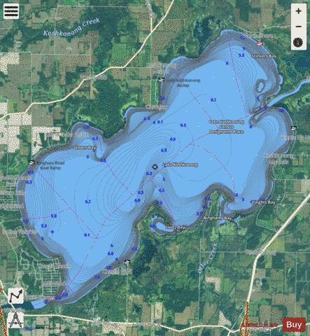
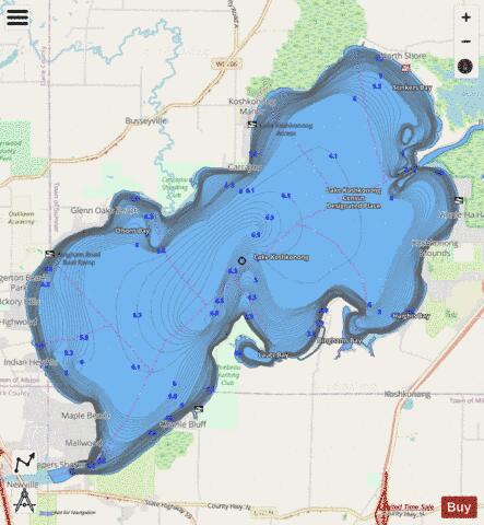
Lake Koshkonong Fishing Map Stats | |
| Title | Lake Koshkonong |
| Scale | 1:12000 |
| Counties | Dane, Jefferson, Rock |
| Nearby Cities | Lake Koshkonong, Koshkonong, Albion, Edgerton, Oakland, Milton, Fort Atkinson, Rockdale, Lake Ripley, Fulton |
| Area * | 10602.22 acres |
| Shoreline * | 30.06 miles |
| Min Longitude | -89.02 |
| Min Latitude | 42.83 |
| Max Longitude | -88.91 |
| Max Latitude | 42.91 |
| Edition Label 1 | |
| Edition Label 2 | |
| Edition Label 3 | |
| Id | US_UB_WI_01567632 |
| Country | US |
| Projection | Mercator |
| * some Stats may include nearby/connecting waterbodies | |
|