Big Cedar Lake fishing map is available as part of iBoating : USA Marine & Fishing App(now supported on multiple platforms including Android, iPhone/iPad, MacBook, and Windows(tablet and phone)/PC based chartplotter.).
With our Lake Maps App, you get all the great marine chart app features like fishing spots, along with Big Cedar Lake depth map. The fishing maps app include HD lake depth contours, along with advanced features found in Fish Finder / Gps Chart Plotter systems, turning your device into a Depth Finder. The Big Cedar Lake Navigation App provides advanced features of a Marine Chartplotter including adjusting water level offset and custom depth shading. Fishing spots and depth contours layers are available in most Lake maps. Lake navigation features include advanced instrumentation to gather wind speed direction, water temperature, water depth, and accurate GPS with AIS receivers(using NMEA over TCP/UDP). Autopilot support can be enabled during ‘Goto WayPoint’ and ‘Route Assistance’.
Now i-Boating supports Fishing Points in Big Cedar Lake.
Have more questions about the Nautical Chart App? Ask us.
Fishing Info for Big Cedar Lake
Big Cedar Lake, a lake located in Washington County, Wisconsin, about a mile west of Little Cedar Lake, is the biggest lake of 52 in Washington County. It has 10.2 miles of shoreline and measures over 900 acres. It is managed by the Big Cedar Lake Protection and Rehabilitation District (BCLPRD), a tax-funded governmental agency with seven commissioners. They provide maintenance, refuse and lake safety services. Fish commonly found in this lake include Northern Pike, Large Mouth Bass, Panfish, and Cisco. The Lake District takes part in Operation Dry Water, an annual initiative aimed at reducing the number of alcohol and drug-related accidents and fatalities and fostering a stronger and more visible deterrent to alcohol and drug use on the water.
More on Wikipedia...Popular fish species in this lake include Cisco (fish) and Panfish.
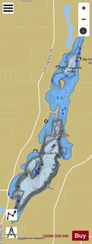
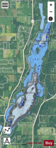
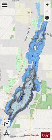
Big Cedar Lake Fishing Map Stats | |
| Title | Big Cedar Lake |
| Sailing Clubs in this Chart region | |
| Cedar Lake Yacht Club | |
| Scale | 1:6000 |
| Counties | Washington |
| Nearby Cities | Slinger, West Bend, Barton, Allenton, Jackson, Kewaskum, Addison, Hartford, Wayne, Richfield |
| Area * | 937.28 acres |
| Shoreline * | 11.44 miles |
| Min Longitude | -88.28 |
| Min Latitude | 43.36 |
| Max Longitude | -88.25 |
| Max Latitude | 43.41 |
| Edition Label 1 | |
| Edition Label 2 | |
| Edition Label 3 | |
| Id | US_UB_WI_01562856 |
| Country | US |
| Projection | Mercator |
| * some Stats may include nearby/connecting waterbodies | |
|