Red Lake(Upper / Lower) fishing map is available as part of iBoating : USA Marine & Fishing App(now supported on multiple platforms including Android, iPhone/iPad, MacBook, and Windows(tablet and phone)/PC based chartplotter.).
With our Lake Maps App, you get all the great marine chart app features like fishing spots, along with Red Lake(Upper / Lower) depth map. The fishing maps app include HD lake depth contours, along with advanced features found in Fish Finder / Gps Chart Plotter systems, turning your device into a Depth Finder. The Red Lake(Upper / Lower) Navigation App provides advanced features of a Marine Chartplotter including adjusting water level offset and custom depth shading. Fishing spots and depth contours layers are available in most Lake maps. Lake navigation features include advanced instrumentation to gather wind speed direction, water temperature, water depth, and accurate GPS with AIS receivers(using NMEA over TCP/UDP). Autopilot support can be enabled during ‘Goto WayPoint’ and ‘Route Assistance’.
Have more questions about the Nautical Chart App? Ask us.
Fishing Info for Red Lake(Upper / Lower)
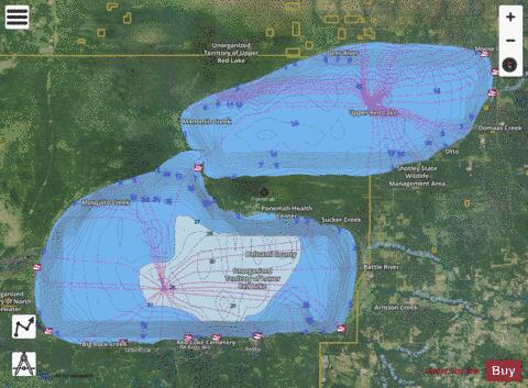
Red Lake (translated from the Ojibwe language Miskwaagamiiwi-zaaga'igan: Lake with its liquid [water] be colored red) is a lake in Beltrami County in northern Minnesota. It is the largest natural freshwater lake located entirely within Minnesota, and the 16th largest lake in the United States. The lake is separated into two sections by a peninsula on the eastern side that almost bisects it in the middle. The community of Ponemah lies on the peninsula. The two parts of the lake are known as Upper Red Lake and Lower Red Lake. Lower Red Lake lies entirely within the Red Lake Indian Reservation. Total size is 444 square miles, with a maximum depth of 35 feet. The elevation of the lake is maintained by a dam at the outflow that is the beginning of Red Lake River, this being at the middle, western edge of Lower Red Lake.
More on Wikipedia...Popular fish species in this lake include Black bullhead, Black crappie, Brown bullhead, Burbot, Freshwater drum, Golden redhorse, Goldeye, Lake sturgeon, Lake trout, Lake whitefish, Largemouth bass, Northern pike, Quillback, Rock bass, Walleye, White sucker and Yellow perch.
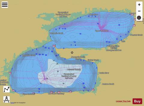
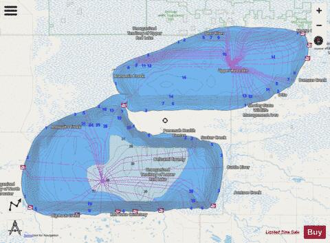
Red Lake(Upper / Lower) Fishing Map Stats | |
| Title | Red Lake(Upper / Lower) |
| Scale | 1:24000 |
| Counties | Beltrami, Clearwater |
| Nearby Cities | Ponemah, Redby, Red Lake, Waskish, Saum, Kelliher, Puposky, Leonard, Hines, Tenstrike |
| Area * | 284019.17 acres |
| Shoreline * | 131.76 miles |
| Min Longitude | -95.28 |
| Min Latitude | 47.87 |
| Max Longitude | -94.52 |
| Max Latitude | 48.21 |
| Edition Label 1 | |
| Edition Label 2 | |
| Edition Label 3 | |
| Id | US_UB_MN_00653561_00647260 |
| Country | US |
| Projection | Mercator |
| * some Stats may include nearby/connecting waterbodies | |
|