Lake Overholser fishing map is available as part of iBoating : USA Marine & Fishing App(now supported on multiple platforms including Android, iPhone/iPad, MacBook, and Windows(tablet and phone)/PC based chartplotter.).
With our Lake Maps App, you get all the great marine chart app features like fishing spots, along with Lake Overholser depth map. The fishing maps app include HD lake depth contours, along with advanced features found in Fish Finder / Gps Chart Plotter systems, turning your device into a Depth Finder. The Lake Overholser Navigation App provides advanced features of a Marine Chartplotter including adjusting water level offset and custom depth shading. Fishing spots and depth contours layers are available in most Lake maps. Lake navigation features include advanced instrumentation to gather wind speed direction, water temperature, water depth, and accurate GPS with AIS receivers(using NMEA over TCP/UDP). Autopilot support can be enabled during ‘Goto WayPoint’ and ‘Route Assistance’.
Now i-Boating supports Fishing Points in Lake Overholser.
Have more questions about the Nautical Chart App? Ask us.
Fishing Info for Lake Overholser
Lake Overholser is a reservoir within the city limits of Oklahoma City, Oklahoma. Lake Overholser is formed by Overholser Dam on the North Canadian River in Oklahoma County, Oklahoma. The lake is 2.9 miles (4.7 km) west of Bethany. Lake Overholser is named after Ed Overholser who was the 16th Mayor of the City of Oklahoma City. The lake was originally intended to assure an adequate supply of municipal water, since the city depended primarily on the North Canadian River as a source, supplemented by private wells. The need for flood control capability became obvious when the river flooded in 1923, it breached the Lake Overholser Dam, and inundated much of the city.
More on Wikipedia...
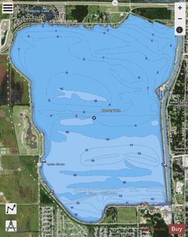
Lake Overholser Fishing Map Stats | |
| Title | Lake Overholser |
| Scale | 1:12000 |
| Counties | Canadian, Oklahoma |
| Nearby Cities | Woodlawn Park, Bethany, Warr Acres, Yukon, Nichols Hills, The Village, Mustang, Oklahoma City, Piedmont, Valley Brook |
| Area * | 1581.61 acres |
| Shoreline * | 7.32 miles |
| Min Longitude | -97.69 |
| Min Latitude | 35.48 |
| Max Longitude | -97.66 |
| Max Latitude | 35.51 |
| Edition Label 1 | |
| Edition Label 2 | |
| Edition Label 3 | |
| Id | US_OK_overholser |
| Country | US |
| Projection | Mercator |
| * some Stats may include nearby/connecting waterbodies | |
|