Blue Mountain Lake fishing map is available as part of iBoating : USA Marine & Fishing App(now supported on multiple platforms including Android, iPhone/iPad, MacBook, and Windows(tablet and phone)/PC based chartplotter.).
With our Lake Maps App, you get all the great marine chart app features like fishing spots, along with Blue Mountain Lake depth map. The fishing maps app include HD lake depth contours, along with advanced features found in Fish Finder / Gps Chart Plotter systems, turning your device into a Depth Finder. The Blue Mountain Lake Navigation App provides advanced features of a Marine Chartplotter including adjusting water level offset and custom depth shading. Fishing spots and depth contours layers are available in most Lake maps. Lake navigation features include advanced instrumentation to gather wind speed direction, water temperature, water depth, and accurate GPS with AIS receivers(using NMEA over TCP/UDP). Autopilot support can be enabled during ‘Goto WayPoint’ and ‘Route Assistance’.
Now i-Boating supports Fishing Points in Blue Mountain Lake.
Have more questions about the Nautical Chart App? Ask us.
Fishing Info for Blue Mountain Lake
Blue Mountain Lake is a 1,334-acre (540 ha) lake in Hamilton County in the central Adirondacks. Blue Mountain Lake is the eastern end of the Eckford chain of lakes. It is located west of Blue Mountain. The hamlet of Blue Mountain Lake lies on its southeastern shore and the Adirondack Museum looks down from high above its eastern shore. It has been a popular vacation destination since the mid-19th century.
More on Wikipedia...Popular fish species in this lake include Lake trout, Rainbow trout and Smallmouth bass.
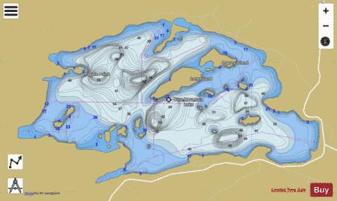
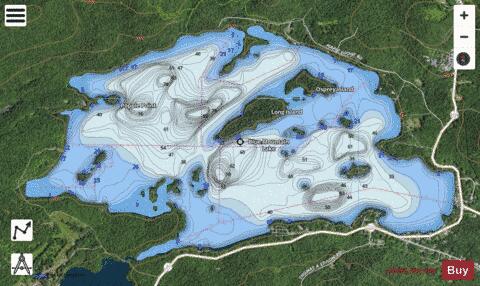
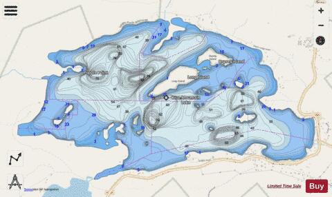
Blue Mountain Lake Fishing Map Stats | |
| Title | Blue Mountain Lake |
| Scale | 1:6000 |
| Counties | Hamilton |
| Nearby Cities | Long Lake, Indian Lake, Raquette Lake, Newcomb, Sabattis, Inlet, Tupper Lake, Speculator, Piercefield, Brandreth |
| Area * | 1235.94 acres |
| Shoreline * | 15.43 miles |
| Min Longitude | -74.48 |
| Min Latitude | 43.85 |
| Max Longitude | -74.43 |
| Max Latitude | 43.87 |
| Edition Label 1 | |
| Edition Label 2 | |
| Edition Label 3 | |
| Id | US_NY_0903_0204 |
| Country | US |
| Projection | Mercator |
| * some Stats may include nearby/connecting waterbodies | |
|