Chain Lake fishing map is available as part of iBoating : USA Marine & Fishing App(now supported on multiple platforms including Android, iPhone/iPad, MacBook, and Windows(tablet and phone)/PC based chartplotter.).
With our Lake Maps App, you get all the great marine chart app features like fishing spots, along with Chain Lake depth map. The fishing maps app include HD lake depth contours, along with advanced features found in Fish Finder / Gps Chart Plotter systems, turning your device into a Depth Finder. The Chain Lake Navigation App provides advanced features of a Marine Chartplotter including adjusting water level offset and custom depth shading. Fishing spots and depth contours layers are available in most Lake maps. Lake navigation features include advanced instrumentation to gather wind speed direction, water temperature, water depth, and accurate GPS with AIS receivers(using NMEA over TCP/UDP). Autopilot support can be enabled during ‘Goto WayPoint’ and ‘Route Assistance’.
Now i-Boating supports Fishing Points in Chain Lake.
Have more questions about the Nautical Chart App? Ask us.
Fishing Info for Chain Lake
Chain Lake is a large pond or small lake in Mackinac County near St. Ignace in the U.S. state of Michigan at an elevation of 600 feet (180 m). The lake is served by Interstate 75, which provides a rest area and lake overlook for southbound drivers at mile 346. The lake is also served by the North Country Trail, running in concurrence with the St. Ignace-Trout Lake Trail. This trail uses the right-of-way abandoned by a spur line of the Duluth, South Shore and Atlantic Railway, a logging-era railroad that helped remove most of the old-growth timber from around the lake. Second-growth woodland surrounding the small sheet of water is owned by the private sector and by Hiawatha National Forest. The lake is noted for rock bass, bullhead, sunfish, sucker, largemouth bass, perch, and northern pike. In winter seasons with suitable weather conditions it can be used to play pond hockey. It may be named for being part of a "chain" of streams and lakes that offered alternative canoe passage from St. Ignace westward. Although the eastern tip of the lake is less than 1 mile from Lake Huron, it drains down the Moran River and through Freschette Lake into West Moran Bay in Lake Michigan.
More on Wikipedia...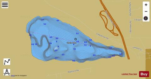
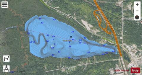
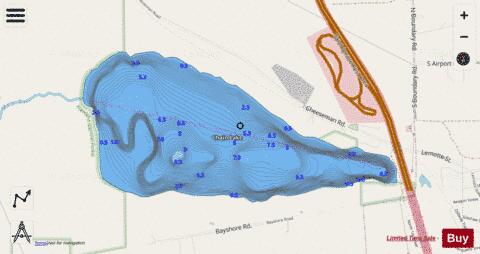
Chain Lake Fishing Map Stats | |
| Title | Chain Lake |
| Scale | 1:12000 |
| Includes Data from Fish Atlas | Yes |
| Counties | Mackinac |
| Nearby Cities | Saint Ignace, Mackinaw City, Mackinac Island, Moran, Carp Lake, Levering, Pointe Aux Pins, Brevort, Pellston, Hessel |
| Area * | 327.36 acres |
| Shoreline * | 3.43 miles |
| Min Longitude | -84.77 |
| Min Latitude | 45.87 |
| Max Longitude | -84.74 |
| Max Latitude | 45.88 |
| Edition Label 1 | |
| Edition Label 2 | |
| Edition Label 3 | |
| Id | US_MI_49_13 |
| Country | US |
| Projection | Mercator |
| * some Stats may include nearby/connecting waterbodies | |
|