Schoodic Lake fishing map is available as part of iBoating : USA Marine & Fishing App(now supported on multiple platforms including Android, iPhone/iPad, MacBook, and Windows(tablet and phone)/PC based chartplotter.).
With our Lake Maps App, you get all the great marine chart app features like fishing spots, along with Schoodic Lake depth map. The fishing maps app include HD lake depth contours, along with advanced features found in Fish Finder / Gps Chart Plotter systems, turning your device into a Depth Finder. The Schoodic Lake Navigation App provides advanced features of a Marine Chartplotter including adjusting water level offset and custom depth shading. Fishing spots and depth contours layers are available in most Lake maps. Lake navigation features include advanced instrumentation to gather wind speed direction, water temperature, water depth, and accurate GPS with AIS receivers(using NMEA over TCP/UDP). Autopilot support can be enabled during ‘Goto WayPoint’ and ‘Route Assistance’.
Now i-Boating supports Fishing Points in Schoodic Lake.
Have more questions about the Nautical Chart App? Ask us.
Fishing Info for Schoodic Lake
Schoodic Lake is a deep Maine lake with a small drainage basin. The lake covers much of the western half of Lake View Plantation. Tributaries drain Orson Bog, Norton Pond, and Jaquith Pond in eastern Brownville. The south end of the lake overflows through Schoodic Stream 5 miles (8.0 km) to the Piscataquis River 13 miles (21 km) upstream of the Piscataquis confluence with the Penobscot River at Howland. The lake provides good habitat for togue, squaretail, and land-locked Atlantic salmon. Fishermen also find smallmouth bass, white sucker and round whitefish.
More on Wikipedia...Popular fish species in this lake include Atlantic salmon, Brook trout, Lake trout, Smallmouth bass and White sucker.
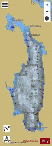
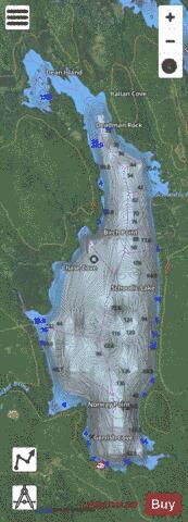
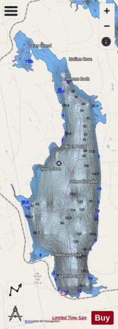
Schoodic Lake Fishing Map Stats | |
| Title | Schoodic Lake |
| Scale | 1:12000 |
| Counties | Piscataquis |
| Nearby Cities | Medford, Brownville, Milo, Brownville Junction, West Seboeis, Lagrange, Sebec, Seboeis, South Lagrange, Norcross |
| Area * | 7026.24 acres |
| Shoreline * | 32.47 miles |
| Min Longitude | -68.96 |
| Min Latitude | 45.32 |
| Max Longitude | -68.90 |
| Max Latitude | 45.44 |
| Edition Label 1 | |
| Edition Label 2 | |
| Edition Label 3 | |
| Id | US_ME_00574999 |
| Country | US |
| Projection | Mercator |
| * some Stats may include nearby/connecting waterbodies | |
|