Flagstaff Lake fishing map is available as part of iBoating : USA Marine & Fishing App(now supported on multiple platforms including Android, iPhone/iPad, MacBook, and Windows(tablet and phone)/PC based chartplotter.).
With our Lake Maps App, you get all the great marine chart app features like fishing spots, along with Flagstaff Lake depth map. The fishing maps app include HD lake depth contours, along with advanced features found in Fish Finder / Gps Chart Plotter systems, turning your device into a Depth Finder. The Flagstaff Lake Navigation App provides advanced features of a Marine Chartplotter including adjusting water level offset and custom depth shading. Fishing spots and depth contours layers are available in most Lake maps. Lake navigation features include advanced instrumentation to gather wind speed direction, water temperature, water depth, and accurate GPS with AIS receivers(using NMEA over TCP/UDP). Autopilot support can be enabled during ‘Goto WayPoint’ and ‘Route Assistance’.
Now i-Boating supports Fishing Points in Flagstaff Lake.
Have more questions about the Nautical Chart App? Ask us.
Fishing Info for Flagstaff Lake
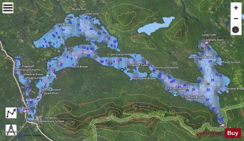
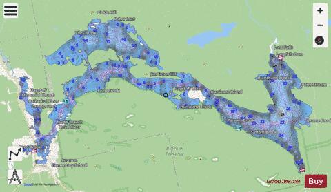
Flagstaff Lake is located in Somerset County and Franklin County, Maine, in the United States. The North Branch Dead River and South Branch Dead River join in the lake, forming the Dead River. The lake's surface area is 20,300 acres (82 km2), and it has a storage capacity of about 275,482 acre-feet. It is extremely shallow (more so during drought years). Its deepest point is 48 feet (15 m). Landlocked salmon and brook trout can be caught. Some points on the lake are very marshy and have to be negotiated with a canoe or kayak; even then, wading may be necessary in the marshy areas to get through to the rest of the lake. Bigelow Mountain Range overlooks from the lake's southern shore, which makes the lake popular for outdoor activities. The lake is mostly undeveloped with relatively few boats and is optimal for kayaking.
More on Wikipedia...Popular fish species in this lake include Brook trout.
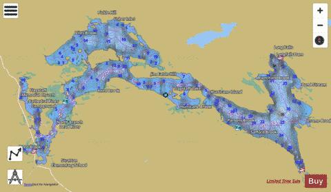
Flagstaff Lake Fishing Map Stats | |
| Title | Flagstaff Lake |
| Scale | 1:12000 |
| Counties | Franklin, Somerset |
| Nearby Cities | Stratton, Eustis, Carrabassett, Kingfield, Caratunk, West Forks, Salem, Rangeley, New Portland, Moscow |
| Area * | 17376.75 acres |
| Shoreline * | 147.20 miles |
| Min Longitude | -70.46 |
| Min Latitude | 45.14 |
| Max Longitude | -70.16 |
| Max Latitude | 45.25 |
| Edition Label 1 | |
| Edition Label 2 | |
| Edition Label 3 | |
| Id | US_ME_00566271 |
| Country | US |
| Projection | Mercator |
| * some Stats may include nearby/connecting waterbodies | |
|