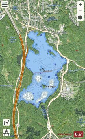
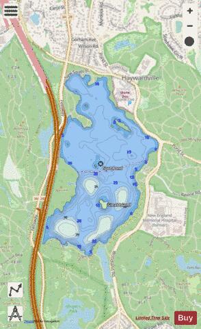
Spot Pond fishing map is available as part of iBoating : USA Marine & Fishing App(now supported on multiple platforms including Android, iPhone/iPad, MacBook, and Windows(tablet and phone)/PC based chartplotter.).
With our Lake Maps App, you get all the great marine chart app features like fishing spots, along with Spot Pond depth map. The fishing maps app include HD lake depth contours, along with advanced features found in Fish Finder / Gps Chart Plotter systems, turning your device into a Depth Finder. The Spot Pond Navigation App provides advanced features of a Marine Chartplotter including adjusting water level offset and custom depth shading. Fishing spots and depth contours layers are available in most Lake maps. Lake navigation features include advanced instrumentation to gather wind speed direction, water temperature, water depth, and accurate GPS with AIS receivers(using NMEA over TCP/UDP). Autopilot support can be enabled during ‘Goto WayPoint’ and ‘Route Assistance’.
Now i-Boating supports Fishing Points in Spot Pond.
Have more questions about the Nautical Chart App? Ask us.
Fishing Info for Spot Pond
Spot Pond is a lake in Middlesex County, in the U.S. state of Massachusetts. The pond is within the Middlesex Fells Reservation, a Massachusetts state park. It is almost entirely located within the boundaries of Stoneham, Massachusetts. Spot Pond was named in 1632 by colonial governor John Winthrop. The pond contains Great Island (42°27′08″N 71°05′46″W / 42.45222°N 71.09616°W), a lake island. Great Island is known to contain an old granite marker with the mysterious inscription "Where Shute Fell". It is unknown who installed the marker, and for what reason. Possibly, it is related to a Wrestler from Haywardsville, as many wrestling matches and prizefights were held on the island. Spot Pond lends its name to the Spot Pond Archeological District, the site of the former Hayward Rubber Works and an extinct mill town. Under the Metropolitan Water Supply Commission (1926-1946), Spot Pond was integrated into the Boston area public drinking water supply. Its water level was raised 16 feet, and the stream running into it was diverted, making its sole supply the new East and West Spot Pond Supply mains. Spot Pond water served the northern Low Service zone, and water pumped from Spot Pond to Fells Reservoir served the Northern High Service zone. Spot Pond is no longer part of the public drinking water supply, but the Massachusetts Water Resources Authority is building covered storage tanks in the area.
More on Wikipedia...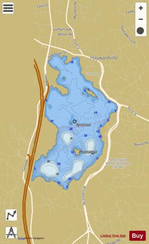
Spot Pond Fishing Map Stats | |
| Title | Spot Pond |
| Scale | 1:6000 |
| Counties | Middlesex |
| Nearby Cities | Stoneham, Melrose, Medford, Winchester, Malden, Wakefield, Woburn, Everett, Somerville, Reading |
| Area * | 289.67 acres |
| Shoreline * | 4.89 miles |
| Min Longitude | -71.10 |
| Min Latitude | 42.45 |
| Max Longitude | -71.09 |
| Max Latitude | 42.46 |
| Edition Label 1 | |
| Edition Label 2 | |
| Edition Label 3 | |
| Id | US_MA_malac_spot_pond |
| Country | US |
| Projection | Mercator |
| * some Stats may include nearby/connecting waterbodies | |
|