Otis Reservoir fishing map is available as part of iBoating : USA Marine & Fishing App(now supported on multiple platforms including Android, iPhone/iPad, MacBook, and Windows(tablet and phone)/PC based chartplotter.).
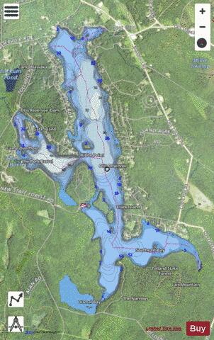
With our Lake Maps App, you get all the great marine chart app features like fishing spots, along with Otis Reservoir depth map. The fishing maps app include HD lake depth contours, along with advanced features found in Fish Finder / Gps Chart Plotter systems, turning your device into a Depth Finder. The Otis Reservoir Navigation App provides advanced features of a Marine Chartplotter including adjusting water level offset and custom depth shading. Fishing spots and depth contours layers are available in most Lake maps. Lake navigation features include advanced instrumentation to gather wind speed direction, water temperature, water depth, and accurate GPS with AIS receivers(using NMEA over TCP/UDP). Autopilot support can be enabled during ‘Goto WayPoint’ and ‘Route Assistance’.
Now i-Boating supports Fishing Points in Otis Reservoir.
Have more questions about the Nautical Chart App? Ask us.
Fishing Info for Otis Reservoir
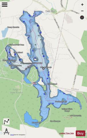
Otis Reservoir is a 1,085-acre (4 km2) reservoir located primarily in Otis, Massachusetts. Small portions are also in Tolland, MA, and Blandford, MA. The lake is popular for boating, swimming, fishing, water skiing, snowmobiling, camping, and water-related recreation. Fish include bass, white perch, yellow perch, tiger muskies, catfish, and bluegills. The reservoir is stocked with trout by the Massachusetts Division of Fisheries & Wildlife. The current lake was formed from the flooding of three ponds, Rand, Little and Msssenger Ponds in 1865, by a dam across the Fall River, a tributary of the Farmington River created by the Farmington River Power Company. It was used for water storage, ensuring a steady supply of water power for mills along the Farmington River. In the early part of the twentieth century, the rise of the automobile led to the development of many seasonal cottages along the lake shore. Building took place along most of the lake shore and on many inland lots. These cottages were fairly inexpensive, being purchased by middle-class people: bankers, barbers, tradesmen, construction contractors, and others. A trend that accelerated in the 1980s was for wealthy people to purchase cottages and upgrade or replace them with expensive second homes. This trend continues. Many people from Connecticut and New York use these as weekend or vacation homes. In addition, many have converted their cottages into year-round residences. Tolland State Forest, a popular camping, boat launch, and swimming area occupies about a quarter of the shoreline. A private campground, Camp Overflow, is also located on the reservoir. A small marina, D&J Marina, also run a boat launch facility on the north side of the lake. The water level is seasonal, being lowered by about 10 feet (3.0 m) over the winter. The reservoir fills in the spring from snow melt and underground springs. The lake is usually at full level by late spring, but in the occasional years of low snow melt and low rainfall, it may remain up to several feet below its typical level. Water is let out of the lake in the fall so that ice will not damage docks and other structures around the lake. This also leads to excellent water quality, as a significant portion of the water is replaced every year.
More on Wikipedia...Popular fish species in this lake include Tiger muskellunge and Yellow perch.
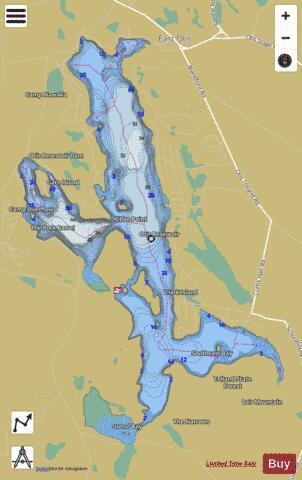
Otis Reservoir Fishing Map Stats | |
| Title | Otis Reservoir |
| Scale | 1:6000 |
| Counties | Berkshire, Hampden |
| Nearby Cities | Otis, Sandisfield, Blandford, Chester, Hartland, Colebrook, Monterey, Becket, Russell, Tyringham |
| Area * | 1037.61 acres |
| Shoreline * | 18.94 miles |
| Min Longitude | -73.06 |
| Min Latitude | 42.13 |
| Max Longitude | -73.02 |
| Max Latitude | 42.17 |
| Edition Label 1 | |
| Edition Label 2 | |
| Edition Label 3 | |
| Id | US_MA_malac_otis_reservoir |
| Country | US |
| Projection | Mercator |
| * some Stats may include nearby/connecting waterbodies | |
|