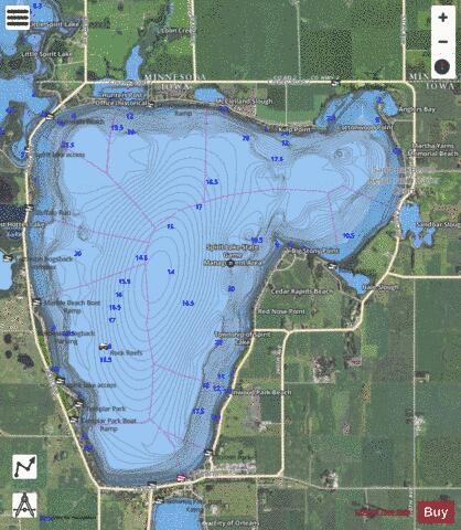
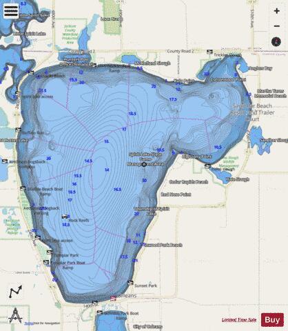
Spirit Lake fishing map is available as part of iBoating : USA Marine & Fishing App(now supported on multiple platforms including Android, iPhone/iPad, MacBook, and Windows(tablet and phone)/PC based chartplotter.).
With our Lake Maps App, you get all the great marine chart app features like fishing spots, along with Spirit Lake depth map. The fishing maps app include HD lake depth contours, along with advanced features found in Fish Finder / Gps Chart Plotter systems, turning your device into a Depth Finder. The Spirit Lake Navigation App provides advanced features of a Marine Chartplotter including adjusting water level offset and custom depth shading. Fishing spots and depth contours layers are available in most Lake maps. Lake navigation features include advanced instrumentation to gather wind speed direction, water temperature, water depth, and accurate GPS with AIS receivers(using NMEA over TCP/UDP). Autopilot support can be enabled during ‘Goto WayPoint’ and ‘Route Assistance’.
Now i-Boating supports Fishing Points in Spirit Lake.
Have more questions about the Nautical Chart App? Ask us.
Fishing Info for Spirit Lake
Big Spirit Lake is a natural body of water, approximately 5,684 acres (2,300 ha) in area, in Dickinson County in northwest Iowa in the United States. It is part of the chain of lakes known as the Iowa Great Lakes, the northern shore of the lake straddles the border with Minnesota. It is the largest natural lake in Iowa. The Dakotah Indian name for the lake was Minnewaukon. Early French traders named it Lac D' Esprit after the Indian legends of an evil spirit who dwelled in the lake. Its maximum depth is 24 feet (7.3 m), and the mean depth is 17 feet (5 m). The drainage area of the lake is approximately 22 square miles (57 km²). It has a drainage area of approximately 75 mi² (194 km²), most of which is in Minnesota.
More on Wikipedia...Popular fish species in this lake include Ameiurus, Crappie, Freshwater drum, Largemouth bass, Northern pike, Smallmouth bass, Walleye and Yellow perch.
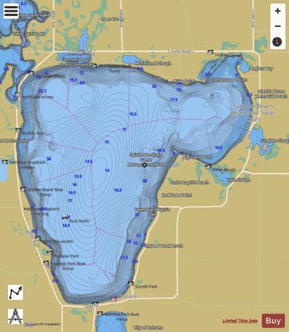
Spirit Lake Fishing Map Stats | |
| Title | Spirit Lake |
| Scale | 1:12000 |
| Counties | Dickinson, Jackson |
| Nearby Cities | Orleans, Spirit Lake, Okoboji, Arnolds Park, Wahpeton, West Okoboji, Superior, Milford, Petersburg, Jackson |
| Area * | 5463.54 acres |
| Shoreline * | 20.61 miles |
| Min Longitude | -95.13 |
| Min Latitude | 43.45 |
| Max Longitude | -95.05 |
| Max Latitude | 43.51 |
| Edition Label 1 | |
| Edition Label 2 | |
| Edition Label 3 | |
| Id | US_IA_00461850 |
| Country | US |
| Projection | Mercator |
| * some Stats may include nearby/connecting waterbodies | |
|