Kingsley fishing map is available as part of iBoating : USA Marine & Fishing App(now supported on multiple platforms including Android, iPhone/iPad, MacBook, and Windows(tablet and phone)/PC based chartplotter.).
With our Lake Maps App, you get all the great marine chart app features like fishing spots, along with Kingsley lake depth map. The fishing maps app include HD lake depth contours, along with advanced features found in Fish Finder / Gps Chart Plotter systems, turning your device into a Depth Finder. The Kingsley Navigation App provides advanced features of a Marine Chartplotter including adjusting water level offset and custom depth shading. Fishing spots and depth contours layers are available in most Lake maps. Lake navigation features include advanced instrumentation to gather wind speed direction, water temperature, water depth, and accurate GPS with AIS receivers(using NMEA over TCP/UDP). Autopilot support can be enabled during ‘Goto WayPoint’ and ‘Route Assistance’.
Now i-Boating supports Fishing Points in Kingsley.
Have more questions about the Nautical Chart App? Ask us.
Fishing Info for Kingsley
Kingsley Lake is an almost perfectly circular lake of about 2,000 acres (810 ha) in North East Florida, is located inside Clay County about six miles (9.7 km) east of Starke, Florida. According to some sources, it is the oldest and highest lake in Florida, located on the edge of the Trail Ridge formation. The lake is a very stable lake with a sandy bottom. Its deepest point is about 100 feet (30 m) inside of a steep sinkhole within the lake. Kingsley Lake is so nearly circular that pilots call it the "silver dollar lake". There are around 180 docks around the lake, mostly around the western half of the lake encompassing the small community of the same name. Camp Blanding is on the eastern side of the lake as part of the Florida National Guard, as well as a small airstrip just to the southeast of the lake as part of Camp Blanding. The lake is about 30 miles northeast of Gainesville, 30 miles southwest of Jacksonville, and 30 miles northwest of Palatka.
More on Wikipedia...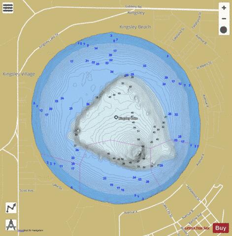
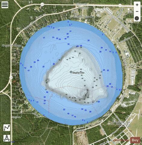
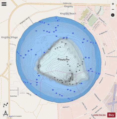
Kingsley Fishing Map Stats | |
| Title | Kingsley |
| Scale | 1:12000 |
| 1 ft Depth Contours for Anglers | Yes |
| Counties | Clay |
| Nearby Cities | Kingsley, Lawtey, Starke, Theressa, Highland, Hampton, Middleburg, Keystone Heights, Penney Farms, Hugh |
| Area * | 1621.05 acres |
| Shoreline * | 5.70 miles |
| Min Longitude | -82.01 |
| Min Latitude | 29.95 |
| Max Longitude | -81.98 |
| Max Latitude | 29.98 |
| Edition Label 1 | |
| Edition Label 2 | |
| Edition Label 3 | |
| Id | US_FL_flsonar_kingsley |
| Country | US |
| Projection | Mercator |
| * some Stats may include nearby/connecting waterbodies | |
|