Glen Charlie Pond fishing map is available as part of iBoating : USA Marine & Fishing App(now supported on multiple platforms including Android, iPhone/iPad, MacBook, and Windows(tablet and phone)/PC based chartplotter.).
With our Lake Maps App, you get all the great marine chart app features like fishing spots, along with Glen Charlie Pond depth map. The fishing maps app include HD lake depth contours, along with advanced features found in Fish Finder / Gps Chart Plotter systems, turning your device into a Depth Finder. The Glen Charlie Pond Navigation App provides advanced features of a Marine Chartplotter including adjusting water level offset and custom depth shading. Fishing spots and depth contours layers are available in most Lake maps. Lake navigation features include advanced instrumentation to gather wind speed direction, water temperature, water depth, and accurate GPS with AIS receivers(using NMEA over TCP/UDP). Autopilot support can be enabled during ‘Goto WayPoint’ and ‘Route Assistance’.
Now i-Boating supports Fishing Points in Glen Charlie Pond.
Have more questions about the Nautical Chart App? Ask us.
Fishing Info for Glen Charlie Pond
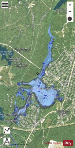
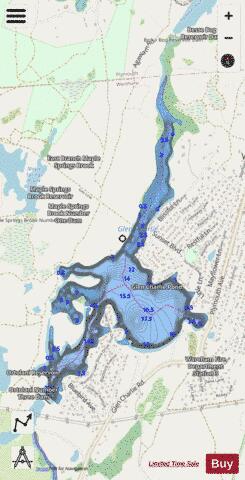
Glen Charlie Pond is a 185-acre (0.75 km2) warm water pond in Wareham, Massachusetts. The maximum depth of the pond is 12 feet (3.7 m). The pond is part of the Agawam River. The pond is located southwest of White Island Shores, northeast of Spectacle Pond, north of Sandy Pond, and approximately 2 miles (3.2 km) north of Route 25. Exit 2 off Route 25 eastbound provides direct access along Glen Charlie Road. The pond is developed with summer and year-round homes mostly along the southern and eastern shores. Public access is possible through town-owned land at the gas pipeline crossing. This pond is popular for both warm-water fishing and ice fishing.
More on Wikipedia...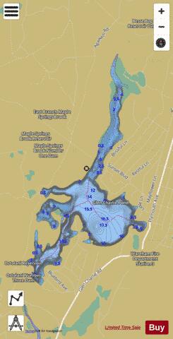
Glen Charlie Pond Fishing Map Stats | |
| Title | Glen Charlie Pond |
| Scale | 1:3000 |
| Counties | Plymouth |
| Nearby Cities | White Island Shores, Onset, Buzzards Bay, Bourne, Wareham, Monument Beach, The Pinehills, Pocasset, West Wareham, Sagamore |
| Area * | 156.64 acres |
| Shoreline * | 6.37 miles |
| Min Longitude | -70.65 |
| Min Latitude | 41.78 |
| Max Longitude | -70.64 |
| Max Latitude | 41.81 |
| Edition Label 1 | |
| Edition Label 2 | |
| Edition Label 3 | |
| Id | US_CC_MA_00615083 |
| Country | US |
| Projection | Mercator |
| * some Stats may include nearby/connecting waterbodies | |
|