Otsego Lake fishing map is available as part of iBoating : USA Marine & Fishing App(now supported on multiple platforms including Android, iPhone/iPad, MacBook, and Windows(tablet and phone)/PC based chartplotter.).
With our Lake Maps App, you get all the great marine chart app features like fishing spots, along with Otsego Lake depth map. The fishing maps app include HD lake depth contours, along with advanced features found in Fish Finder / Gps Chart Plotter systems, turning your device into a Depth Finder. The Otsego Lake Navigation App provides advanced features of a Marine Chartplotter including adjusting water level offset and custom depth shading. Fishing spots and depth contours layers are available in most Lake maps. Lake navigation features include advanced instrumentation to gather wind speed direction, water temperature, water depth, and accurate GPS with AIS receivers(using NMEA over TCP/UDP). Autopilot support can be enabled during ‘Goto WayPoint’ and ‘Route Assistance’.
Now i-Boating supports Fishing Points in Otsego Lake.
Have more questions about the Nautical Chart App? Ask us.
Fishing Info for Otsego Lake
Otsego Lake is a 4,046-acre (16.37 km2) lake located in Otsego County in the U.S. state of New York. It is the source of the Susquehanna River and largest lake in Otsego County. The Village of Cooperstown is located at the lake's southern end. Glimmerglass State Park is located on the lake's northeastern shore, and includes Hyde Hall, a large mansion constructed in 1817, that overlooks the lake. The Glimmerglass Opera, opened in June 1987, is located on the western shore. Between 10,000 and 12,000 years ago, glaciers of the Wisconsin glaciation filled the valley. Otsego Lake was formed when an ice tongue from a glacier carved out the Susquehanna River Valley. As the glaciers melted slowly, they filled in the valley they carved out. The lake takes its name from the Iroquois Indians, who inhabited the area around the lake in and before the 17th century. The name Otsego is from a Mohawk or Oneida word meaning "place of the rock", referring to the large boulder near the lake's outlet, today known as Council Rock. The lake's role in the state and local economy has led to a concentrated effort to protect and manage it. In 1935, the New York State Conservation Department performed the first biological survey of Otsego Lake. In 1968, the State University of New York at Oneonta (SUNY Oneonta) gained access to the lake, a location to build a field station and a biological research facility. Also at this time, the Otsego County Conservation Association (OCCA) was formed by a group of local landowners and sportsmen concerned about the water quality. SUNY Oneonta and OCCA collaborate on water quality improvement projects. The Otsego Lake Association, a not for profit group, makes sure that the Otsego Lake Watershed Management Plan is enforced. Today the lake is used for pleasure as well as sporting activities such as fishing.
More on Wikipedia...Popular fish species in this lake include Atlantic salmon, Chain pickerel, Lake trout, Lake whitefish, Largemouth bass, Pumpkinseed, Rock bass, Smallmouth bass, Walleye and Yellow perch.
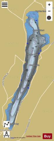
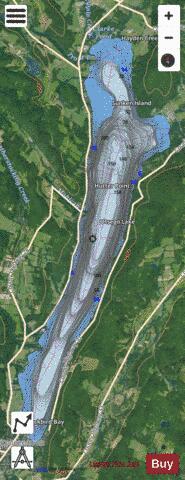
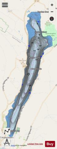
Otsego Lake Fishing Map Stats | |
| Title | Otsego Lake |
| Scale | 1:12000 |
| Counties | Otsego |
| Nearby Cities | Cooperstown, Springfield, Warren, Middlefield, Richfield Springs, Roseboom, Milford, Cherry Valley, Schuyler Lake, Westford |
| Area * | 4152.33 acres |
| Shoreline * | 19.86 miles |
| Min Longitude | -74.93 |
| Min Latitude | 42.70 |
| Max Longitude | -74.87 |
| Max Latitude | 42.81 |
| Edition Label 1 | |
| Edition Label 2 | |
| Edition Label 3 | |
| Id | US_AA_NY_otsego_lake_ny |
| Country | US |
| Projection | Mercator |
| * some Stats may include nearby/connecting waterbodies | |
|