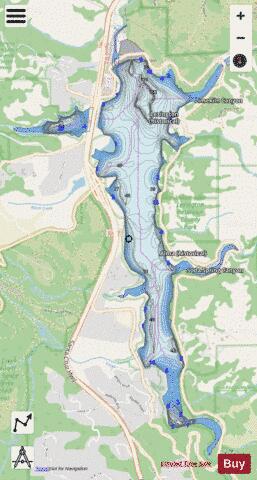
Lexington Reservoir fishing map is available as part of iBoating : USA Marine & Fishing App(now supported on multiple platforms including Android, iPhone/iPad, MacBook, and Windows(tablet and phone)/PC based chartplotter.).
With our Lake Maps App, you get all the great marine chart app features like fishing spots, along with Lexington Reservoir depth map. The fishing maps app include HD lake depth contours, along with advanced features found in Fish Finder / Gps Chart Plotter systems, turning your device into a Depth Finder. The Lexington Reservoir Navigation App provides advanced features of a Marine Chartplotter including adjusting water level offset and custom depth shading. Fishing spots and depth contours layers are available in most Lake maps. Lake navigation features include advanced instrumentation to gather wind speed direction, water temperature, water depth, and accurate GPS with AIS receivers(using NMEA over TCP/UDP). Autopilot support can be enabled during ‘Goto WayPoint’ and ‘Route Assistance’.
Now i-Boating supports Fishing Points in Lexington Reservoir.
Have more questions about the Nautical Chart App? Ask us.
Fishing Info for Lexington Reservoir
Lexington Reservoir is an artificial lake on the Los Gatos Creek near Los Gatos, California. The James J. Lenihan Dam, a 195 ft (59 m) high, 1,000 ft (300 m) thick earthen dam, forms the third-largest reservoir in Santa Clara County.
More on Wikipedia...Popular fish species in this lake include Crappie.

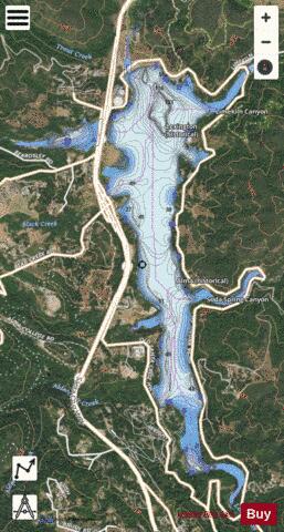
Lexington Reservoir Fishing Map Stats | |
| Title | Lexington Reservoir |
| Scale | 1:12000 |
| Counties | Santa Clara |
| Nearby Cities | Los Gatos, Monte Sereno, Saratoga, Cambrian Park, Campbell, Lompico, Zayante, Rancho Rinconada, Scotts Valley, Cupertino |
| Area * | 353.95 acres |
| Shoreline * | 10.56 miles |
| Min Longitude | -122.00 |
| Min Latitude | 37.17 |
| Max Longitude | -121.98 |
| Max Latitude | 37.20 |
| Edition Label 1 | |
| Edition Label 2 | |
| Edition Label 3 | |
| Id | US_AA_CA_lexington_reservoir_ca |
| Country | US |
| Projection | Mercator |
| * some Stats may include nearby/connecting waterbodies | |
|