Kaweah Lake fishing map is available as part of iBoating : USA Marine & Fishing App(now supported on multiple platforms including Android, iPhone/iPad, MacBook, and Windows(tablet and phone)/PC based chartplotter.).
With our Lake Maps App, you get all the great marine chart app features like fishing spots, along with Kaweah Lake depth map. The fishing maps app include HD lake depth contours, along with advanced features found in Fish Finder / Gps Chart Plotter systems, turning your device into a Depth Finder. The Kaweah Lake Navigation App provides advanced features of a Marine Chartplotter including adjusting water level offset and custom depth shading. Fishing spots and depth contours layers are available in most Lake maps. Lake navigation features include advanced instrumentation to gather wind speed direction, water temperature, water depth, and accurate GPS with AIS receivers(using NMEA over TCP/UDP). Autopilot support can be enabled during ‘Goto WayPoint’ and ‘Route Assistance’.
Now i-Boating supports Fishing Points in Kaweah Lake.
Have more questions about the Nautical Chart App? Ask us.
Fishing Info for Kaweah Lake
Lake Kaweah is a reservoir near Lemon Cove in Tulare County, California. The lake is formed by Terminus Dam on the Kaweah River. The river originates in the Sierra Nevada and drains about 560 sq mi (1,500 km2) into Lake Kaweah before flowing towards the San Joaquin Valley. From Lake Kaweah, the river flows toward the city of Visalia, splitting into the Kaweah River and St. Johns River as it flows west into the Tulare Lakebed. The lake has a capacity of 185,000 acre⋅ft (228,000,000 m3). A project to raise the lake 21 ft (6.4 m) was completed in 2004. The lake now impounds an additional 42,000 acre⋅ft (52,000,000 m3) and downstream flood protection to downstream communities and agricultural land has been increased. Because its primary purpose is flood control, Lake Kaweah is maintained at a very low level or empty for most of the year, and generally only fills between May and June. Due to the limited capacity of the reservoir, large spills of floodwater often occur after large rain storms. In the winter, water is released as quickly as possible to ensure room for floodwater which can then be released at a controlled rate. During floods in 1997, the reservoir filled and emptied twice because of this operational regimen. At the upper end of Lake Kaweah is the small town of Three Rivers, which sits at the entrance to Sequoia National Park.
More on Wikipedia...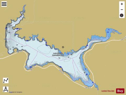
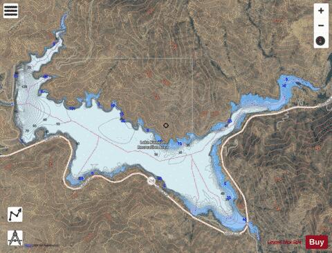
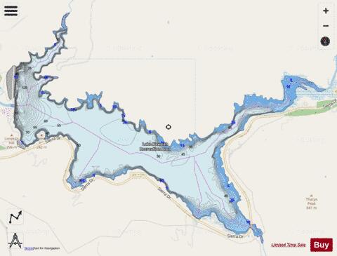
Kaweah Lake Fishing Map Stats | |
| Title | Kaweah Lake |
| Scale | 1:12000 |
| Counties | Tulare |
| Nearby Cities | Lemoncove, Three Rivers, Lemon Cove, Kaweah, Lindcove, Woodlake, Elderwood, Tooleville, Exeter, Tonyville |
| Area * | 1863.23 acres |
| Shoreline * | 21.41 miles |
| Min Longitude | -119.00 |
| Min Latitude | 36.39 |
| Max Longitude | -118.93 |
| Max Latitude | 36.43 |
| Edition Label 1 | |
| Edition Label 2 | |
| Edition Label 3 | |
| Id | US_AA_CA_kaweah_lake |
| Country | US |
| Projection | Mercator |
| * some Stats may include nearby/connecting waterbodies | |
|