French Meadows Reservoir fishing map is available as part of iBoating : USA Marine & Fishing App(now supported on multiple platforms including Android, iPhone/iPad, MacBook, and Windows(tablet and phone)/PC based chartplotter.).
With our Lake Maps App, you get all the great marine chart app features like fishing spots, along with French Meadows Reservoir depth map. The fishing maps app include HD lake depth contours, along with advanced features found in Fish Finder / Gps Chart Plotter systems, turning your device into a Depth Finder. The French Meadows Reservoir Navigation App provides advanced features of a Marine Chartplotter including adjusting water level offset and custom depth shading. Fishing spots and depth contours layers are available in most Lake maps. Lake navigation features include advanced instrumentation to gather wind speed direction, water temperature, water depth, and accurate GPS with AIS receivers(using NMEA over TCP/UDP). Autopilot support can be enabled during ‘Goto WayPoint’ and ‘Route Assistance’.
Now i-Boating supports Fishing Points in French Meadows Reservoir.
Have more questions about the Nautical Chart App? Ask us.
Fishing Info for French Meadows Reservoir
French Meadows Reservoir is a manmade lake 36 miles (58 km) northeast of Foresthill, California, United States on the Middle Fork of the American River. The reservoir is 2.9 miles (4.7 km) long, 0.6-mile (0.97 km) wide, with 7.3 miles (11.7 km) of shoreline. Tahoe National Forest manages the recreational facilities which include five campgrounds, two group campgrounds and two paved boat launch ramps. Activities at the lake include powerboating, kayaking, canoeing, fishing, picnicking and hiking. The reservoir is entirely within a state game refuge so no firearms, pellet guns or archery weapons are allowed. The elevation of the lake is 5,263 feet (1,604 m), and it is nine miles (14 km) from the crest of the Sierra Nevada Mountain Range. The California Office of Environmental Health Hazard Assessment (OEHHA) has developed a safe eating advisory for French Meadows Reservoir based on levels of mercury found in fish caught here.
More on Wikipedia...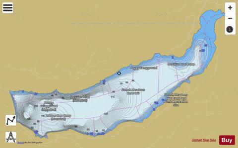
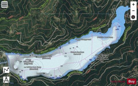
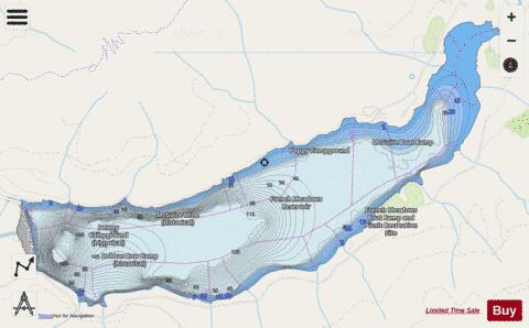
French Meadows Reservoir Fishing Map Stats | |
| Title | French Meadows Reservoir |
| Scale | 1:12000 |
| Counties | Placer |
| Nearby Cities | Kingvale, Soda Springs, Emigrant Gap, Tahoe City, Blue Canyon, Tahoma, Truckee, Meeks Bay, Dollar Point, Carnelian Bay |
| Area * | 1419.50 acres |
| Shoreline * | 10.22 miles |
| Min Longitude | -120.47 |
| Min Latitude | 39.10 |
| Max Longitude | -120.41 |
| Max Latitude | 39.13 |
| Edition Label 1 | |
| Edition Label 2 | |
| Edition Label 3 | |
| Id | US_AA_CA_frenchmeadows_ca |
| Country | US |
| Projection | Mercator |
| * some Stats may include nearby/connecting waterbodies | |
|