Black Butte Lake fishing map is available as part of iBoating : USA Marine & Fishing App(now supported on multiple platforms including Android, iPhone/iPad, MacBook, and Windows(tablet and phone)/PC based chartplotter.).
With our Lake Maps App, you get all the great marine chart app features like fishing spots, along with Black Butte Lake depth map. The fishing maps app include HD lake depth contours, along with advanced features found in Fish Finder / Gps Chart Plotter systems, turning your device into a Depth Finder. The Black Butte Lake Navigation App provides advanced features of a Marine Chartplotter including adjusting water level offset and custom depth shading. Fishing spots and depth contours layers are available in most Lake maps. Lake navigation features include advanced instrumentation to gather wind speed direction, water temperature, water depth, and accurate GPS with AIS receivers(using NMEA over TCP/UDP). Autopilot support can be enabled during ‘Goto WayPoint’ and ‘Route Assistance’.
Now i-Boating supports Fishing Points in Black Butte Lake.
Have more questions about the Nautical Chart App? Ask us.
Fishing Info for Black Butte Lake
Black Butte Lake is an artificial lake located in Tehama and Glenn counties in the U.S. state of California. The lake was formed from Stony Creek in 1963 upon the completion of Black Butte Dam by the U.S. Army Corps of Engineers. The dam is located approximately 9 miles (14.5 km) west of Orland. At full pool, the lake is 7 miles (11.3 km) long and has a shoreline of 40 miles (64.4 km) and a surface area of 4,460 acres (18 km2). The dam and lake were constructed for flood protection for local towns and agricultural lands. The California Office of Environmental Health Hazard Assessment released a warning regarding eating fish caught from this lake based on the elevated mercury level.
More on Wikipedia...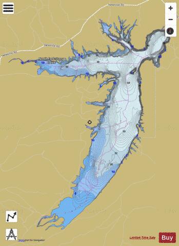
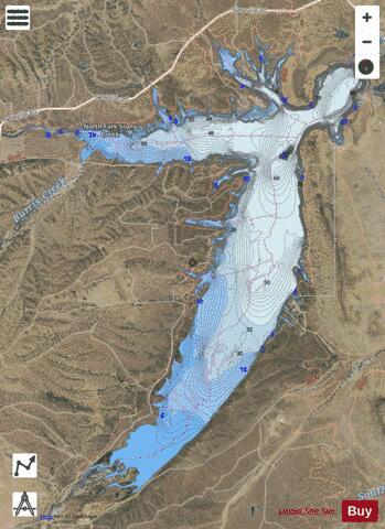
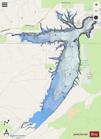
Black Butte Lake Fishing Map Stats | |
| Title | Black Butte Lake |
| Scale | 1:24000 |
| Counties | Glenn, Tehama |
| Nearby Cities | Newville, Flournoy, Paskenta, Orland, Elk Creek, Corning, Rancho Tehama Reserve, Artois, Richfield, Willows |
| Area * | 4306.88 acres |
| Shoreline * | 50.79 miles |
| Min Longitude | -122.42 |
| Min Latitude | 39.74 |
| Max Longitude | -122.34 |
| Max Latitude | 39.82 |
| Edition Label 1 | |
| Edition Label 2 | |
| Edition Label 3 | |
| Id | US_AA_CA_blackbutte_lake_california |
| Country | US |
| Projection | Mercator |
| * some Stats may include nearby/connecting waterbodies | |
|