Fjergen fishing map is included in ֳ˜stfold nautical charts folio. It is available as part of iBoating : Norway Marine & Fishing App (now supported on multiple platforms including Android, iPhone/iPad, MacBook, and Windows(tablet and phone)/PC based chartplotter. ).
With our Lake Maps App, you get all the great marine chart app features like fishing spots, along with Fjergen lake depth map. The fishing maps app include HD lake depth contours, along with advanced features found in Fish Finder / Gps Chart Plotter systems, turning your device into a Depth Finder. The Fjergen Navigation App provides advanced features of a Marine Chartplotter including adjusting water level offset and custom depth shading. Fishing spots and depth contours layers are available in most Lake maps. Lake navigation features include advanced instrumentation to gather wind speed direction, water temperature, water depth, and accurate GPS with AIS receivers(using NMEA over TCP/UDP). Autopilot support can be enabled during ג€˜Goto WayPointג€™ and ג€˜Route Assistanceג€™.
Have more questions about the Nautical Chart App? Ask us.
Fishing Info for Fjergen
Fjergen is a lake in the municipality of Merֳ¥ker in Trֳ¸ndelag county, Norway. The 14.41-square-kilometre (5.56 sq mi) lake has a hydropower dam on the southern end which flows out into the Kֳ¥pperֳ¥a river which is part of the Stjֳ¸rdalselva river system. There is about 204,000,000 cubic metres (7.2ֳ—109 cu ft) of water stored in the lake. The lake is located about 5 kilometres (3.1 mi) north of the village of Kopperֳ¥ and about 7 kilometres (4.3 mi) northeast of the municipal center of Midtbygda. The lakes Feren and Funnsjֳ¸en lie several kilometers to the northwest, and the border with Sweden lies a few kilometers to the east.
More on Wikipedia...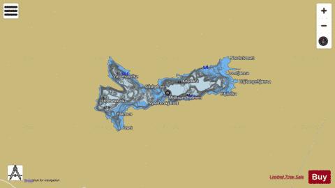
Fjergen Fishing Map Stats | |
| Title | Fjergen |
| Scale | 1:24000 |
| Min Longitude | 11.88 |
| Min Latitude | 63.43 |
| Max Longitude | 12.07 |
| Max Latitude | 63.48 |
| Edition Label 1 | |
| Edition Label 2 | |
| Edition Label 3 | |
| Id | NO_LK_737 |
| Country | Norway |
| Projection | Mercator |
| * some Stats may include nearby/connecting waterbodies | |
|