Bogstadvannet fishing map is included in ֳ˜stfold nautical charts folio. It is available as part of iBoating : Norway Marine & Fishing App (now supported on multiple platforms including Android, iPhone/iPad, MacBook, and Windows(tablet and phone)/PC based chartplotter. ).
With our Lake Maps App, you get all the great marine chart app features like fishing spots, along with Bogstadvannet lake depth map. The fishing maps app include HD lake depth contours, along with advanced features found in Fish Finder / Gps Chart Plotter systems, turning your device into a Depth Finder. The Bogstadvannet Navigation App provides advanced features of a Marine Chartplotter including adjusting water level offset and custom depth shading. Fishing spots and depth contours layers are available in most Lake maps. Lake navigation features include advanced instrumentation to gather wind speed direction, water temperature, water depth, and accurate GPS with AIS receivers(using NMEA over TCP/UDP). Autopilot support can be enabled during ג€˜Goto WayPointג€™ and ג€˜Route Assistanceג€™.
Have more questions about the Nautical Chart App? Ask us.
Fishing Info for Bogstadvannet
Bogstadvannet (English: Lake Bogstad) is a lake between the city of Oslo and the municipality of Bֳ¦rum, Akershus, Norway. It is part of , which in turn is part of . Originally, the lake was named Fֳ¥(d)vannet after an earlier name for Lysakerelven, but has since taken the name of the Bogstad estate and manor, on the east shore of the lake. In addition to the manor, Norway's first 18-hole golf course (from 1924) is owned and operated by on the south shore and a large camping ground on the east shore south of the manor. The lake is a popular destination for swimming and sunbathing in the summer. In winter, inhabitants from all Oslo go skiing and skating on the lake and the surrounding area when conditions permit. It is also a venue for Christiania Roklub, a rowing club. During the occupation of Norway by Nazi Germany from 1940 to 1945, the camping ground was used for military barracks. Structures from this time remained under Norwegian military administration until the 1950s. The lake is shallow with significant flow. Algae growth is not significant, making for good bathing conditions. The environmental condition has remained stable for at least the last 20 years. The commercial development of Bogstadvannet was largely due to the works of the Bogstad estate. The Leucht family, succeeded by the Anker family, built a significant forestry enterprise in the area, and for many years the lake served as part of the waterway for floating lumber to mills along Lysakerelven.
More on Wikipedia...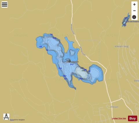
Bogstadvannet Fishing Map Stats | |
| Title | Bogstadvannet |
| Scale | 1:12000 |
| Min Longitude | 10.60 |
| Min Latitude | 59.96 |
| Max Longitude | 10.64 |
| Max Latitude | 59.98 |
| Edition Label 1 | |
| Edition Label 2 | |
| Edition Label 3 | |
| Id | NO_LK_5252 |
| Country | Norway |
| Projection | Mercator |
| * some Stats may include nearby/connecting waterbodies | |
| |||||||||||||||||||||||||||||||||||||||||||||||||||||||||||||||||||||||||||||||||||||||||||||||||||||||
|