Totak fishing map is included in ֳ˜stfold nautical charts folio. It is available as part of iBoating : Norway Marine & Fishing App (now supported on multiple platforms including Android, iPhone/iPad, MacBook, and Windows(tablet and phone)/PC based chartplotter. ).
With our Lake Maps App, you get all the great marine chart app features like fishing spots, along with Totak lake depth map. The fishing maps app include HD lake depth contours, along with advanced features found in Fish Finder / Gps Chart Plotter systems, turning your device into a Depth Finder. The Totak Navigation App provides advanced features of a Marine Chartplotter including adjusting water level offset and custom depth shading. Fishing spots and depth contours layers are available in most Lake maps. Lake navigation features include advanced instrumentation to gather wind speed direction, water temperature, water depth, and accurate GPS with AIS receivers(using NMEA over TCP/UDP). Autopilot support can be enabled during ג€˜Goto WayPointג€™ and ג€˜Route Assistanceג€™.
Have more questions about the Nautical Chart App? Ask us.
Fishing Info for Totak
Totak is a lake in the municipality of Vinje in Vestfold og Telemark county, Norway. The lake is part of the Skien river watershed (Skiensvassdraget), discharging via the river Tokke to lake Bandak. At 306 m Totak is the 10th deepest lake in Norway; this tremendous overdeepening marks it as a glacially formed lake with characteristics similar to a fjord. Its volume of 2.36 km3 makes it the 20th largest by volume as well. It is part of the Tokke Hydroelectric Power Station.
More on Wikipedia...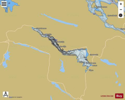
Totak Fishing Map Stats | |
| Title | Totak |
| Scale | 1:24000 |
| Min Longitude | 7.71 |
| Min Latitude | 59.65 |
| Max Longitude | 8.06 |
| Max Latitude | 59.78 |
| Edition Label 1 | |
| Edition Label 2 | |
| Edition Label 3 | |
| Id | NO_LK_9 |
| Country | Norway |
| Projection | Mercator |
| * some Stats may include nearby/connecting waterbodies | |
|