Bygdin fishing map is included in ֳ˜stfold nautical charts folio. It is available as part of iBoating : Norway Marine & Fishing App (now supported on multiple platforms including Android, iPhone/iPad, MacBook, and Windows(tablet and phone)/PC based chartplotter. ).
With our Lake Maps App, you get all the great marine chart app features like fishing spots, along with Bygdin lake depth map. The fishing maps app include HD lake depth contours, along with advanced features found in Fish Finder / Gps Chart Plotter systems, turning your device into a Depth Finder. The Bygdin Navigation App provides advanced features of a Marine Chartplotter including adjusting water level offset and custom depth shading. Fishing spots and depth contours layers are available in most Lake maps. Lake navigation features include advanced instrumentation to gather wind speed direction, water temperature, water depth, and accurate GPS with AIS receivers(using NMEA over TCP/UDP). Autopilot support can be enabled during ג€˜Goto WayPointג€™ and ג€˜Route Assistanceג€™.
Have more questions about the Nautical Chart App? Ask us.
Fishing Info for Bygdin
Bygdin is a lake in Vang Municipality in Innlandet county, Norway. The 46-square-kilometre (18 sq mi) is located in the southern part of the Jotunheimen mountain range. The 25-kilometre (16 mi) long, narrow mountain lake is located between the large lakes Tyin (to the west) and Vinstre to the east. The depth of Bygdin is regulated for hydroelectric power generation at nearby power plants. The normal level of the water lies between 1,048ג€“1,057 metres (3,438ג€“3,468 ft) above sea level. The maximum depth of the lake is 215 metres (705 ft). The Vinsterֳ¥ni river runs out Bygdin, passes through the Vinstre and Vinstervatna lakes and into the river Vinstra. That river later flows into the Gudbrandsdalslֳ¥gen river. Bygdin lies to the southeast part of the Jotunheimen and north of the lake lies a mountainous area that often reaches elevations over 2,000 metres (6,600 ft). Some of the notable mountains located along the shores of the lake include Galdeberget, Torfinnstindene, and Nֳ¸rdre Kalvehֳ¸lotinden. Along the lake there are many tourist huts. On the west end lies Eidsbugarden, on the north side lies the cabins at Torfinnsbu and on the east side lies the mountain hotel Bygdin Hֳ¸yfjellshotell. In the summer, these huts are connected by boat and in winter by ski or snowmobile. A memorial was raised in 1909 to the Norwegian poet Aasmund Olavsson Vinje (1818-1870) at the western end of Bygdin at Eidsbugarden on the outskirts of Jotunheim National Park where he had a private hut. Friends and followers commemorated his contribution to appreciation of Norwegian nature and strengthening of the Norwegian national identity. Today, Eidsbugarden is a rather large mountain tourist centre, with a hotel from 1909 which is being restored to reopen in the summer 2007, a Norwegian Mountain Touring Association (DNT) cabin and approximately 160 private huts.
More on Wikipedia...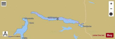
Bygdin Fishing Map Stats | |
| Title | Bygdin |
| Scale | 1:24000 |
| Min Longitude | 8.30 |
| Min Latitude | 61.31 |
| Max Longitude | 8.80 |
| Max Latitude | 61.38 |
| Edition Label 1 | |
| Edition Label 2 | |
| Edition Label 3 | |
| Id | NO_LK_146 |
| Country | Norway |
| Projection | Mercator |
| * some Stats may include nearby/connecting waterbodies | |
|