Dingevatnet fishing map is included in ֳ˜stfold nautical charts folio. It is available as part of iBoating : Norway Marine & Fishing App (now supported on multiple platforms including Android, iPhone/iPad, MacBook, and Windows(tablet and phone)/PC based chartplotter. ).
With our Lake Maps App, you get all the great marine chart app features like fishing spots, along with Dingevatnet lake depth map. The fishing maps app include HD lake depth contours, along with advanced features found in Fish Finder / Gps Chart Plotter systems, turning your device into a Depth Finder. The Dingevatnet Navigation App provides advanced features of a Marine Chartplotter including adjusting water level offset and custom depth shading. Fishing spots and depth contours layers are available in most Lake maps. Lake navigation features include advanced instrumentation to gather wind speed direction, water temperature, water depth, and accurate GPS with AIS receivers(using NMEA over TCP/UDP). Autopilot support can be enabled during ג€˜Goto WayPointג€™ and ג€˜Route Assistanceג€™.
Have more questions about the Nautical Chart App? Ask us.
Fishing Info for Dingevatnet
Dingevatn or Dingevatnet is the 18th deepest lake in Norway, reaching a maximum depth of 220 metres (720 ft). It is located in the municipality of Gulen in Vestland county. The 2.84-square-kilometre (1.10 sq mi) lake is located just east of the village of Dingja, about 1 kilometre (0.62 mi) southeast of the mouth of the Sognefjorden. The lake lies about 4 kilometres (2.5 mi) north of the municipal center of Eivindvik. The lake flows out into the small Dingjaelva river, which runs past the village of Dingja before emptying into the Sognesjֳ¸en strait.
More on Wikipedia...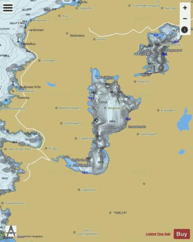
Dingevatnet Fishing Map Stats | |
| Title | Dingevatnet |
| Scale | 1:12000 |
| Min Longitude | 5.06 |
| Min Latitude | 61.02 |
| Max Longitude | 5.11 |
| Max Latitude | 61.05 |
| Edition Label 1 | |
| Edition Label 2 | |
| Edition Label 3 | |
| Id | NO_LK_1446 |
| Country | Norway |
| Projection | Mercator |
| * some Stats may include nearby/connecting waterbodies | |
| |||||||||||||||||||||||||||||||||||||||||||||||||||||||||||||||||||||||||||||||||||||||||||||||||||||||
|