Loch Of Lintrathen fishing map is included in Scotland - Angus Lochs nautical charts folio. It is available as part of iBoating : Inland Europe Marine & Fishing App (now supported on multiple platforms including Android, iPhone/iPad, MacBook, and Windows(tablet and phone)/PC based chartplotter. ).
With our Lake Maps App, you get all the great marine chart app features like fishing spots, along with Loch Of Lintrathen lake depth map. The fishing maps app include HD lake depth contours, along with advanced features found in Fish Finder / Gps Chart Plotter systems, turning your device into a Depth Finder. The Loch Of Lintrathen Navigation App provides advanced features of a Marine Chartplotter including adjusting water level offset and custom depth shading. Fishing spots and depth contours layers are available in most Lake maps. Lake navigation features include advanced instrumentation to gather wind speed direction, water temperature, water depth, and accurate GPS with AIS receivers(using NMEA over TCP/UDP). Autopilot support can be enabled during ‘Goto WayPoint’ and ‘Route Assistance’.
Have more questions about the Nautical Chart App? Ask us.
Fishing Info for Loch Of Lintrathen
Loch of Lintrathen is a man-made loch occupying a glacial basin at the southern end of Glen Isla, approximately 13 kilometres (8.1 mi) west of town of Kirriemuir in Angus, Scotland. The small village of Bridgend of Lintrathen lies on the southern shore of the loch, which is owned by Scottish Water and used as a water supply reservoir as well as an important wildlife site. The loch has been the main water supply for the city of Dundee and Angus since 1875. The water in the Loch of Lintrathen feeds down from Backwater Reservoir 4 kilometres (2.5 mi) to the north and exits it via sluices at Bridgend of Lintrathen, flowing southward past Lintrathen Mill in the ‘Melgam Water’, which has a confluence with the River Isla 3 kilometres (1.9 mi) farther south at Airlie Castle. The loch has a surface area of 151.1 hectares (373 acres) and its dam is an earthworks dam. Loch of Lintrathen is a mid-altitude oligotrophic-mesotrophic loch, which supports large numbers of birds. There are internationally important numbers of greylag geese, with 3% of the Iceland population over-wintering at the site. Other wildlife includes whooper swans, otters and osprey, and the loch is used for trout fishing. The fishing is managed by the Lintrathen Angling Club and both brown and rainbow trout are fished for. As well as being recognised as a wetland of international importance under the Ramsar Convention, Loch of Lintrathen has also been designated a Special Protection Area and a Site of Special Scientific Interest. The Ramsar Site includes an area of marshland in the north-west, a total of 217 hectares being protected. The loch and surrounding area is also maintained as a nature reserve by the Scottish Wildlife Trust.
More on Wikipedia...Popular fish species in this lake include Rainbow trout.
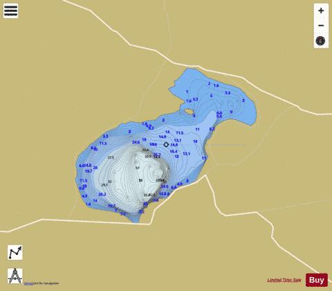
Loch Of Lintrathen Fishing Map Stats | |
| Title | Loch Of Lintrathen |
| Scale | 1:12000 |
| Area * | 421.59 acres |
| Shoreline * | 4.27 miles |
| Min Longitude | -3.20 |
| Min Latitude | 56.67 |
| Max Longitude | -3.16 |
| Max Latitude | 56.69 |
| Edition Label 1 | |
| Edition Label 2 | |
| Edition Label 3 | |
| Id | II_SCOT_74422157_4_scot |
| Country | Inland Europe |
| Projection | Mercator |
| * some Stats may include nearby/connecting waterbodies | |
| ||||||||||||||||||||||||||||||||||||||||||||||||||||||||||||||||||||||||||||||||||||||||||||||||||||||||
|