Loch Arkaig fishing map is included in Scotland - Highland Lochs nautical charts folio. It is available as part of iBoating : Inland Europe Marine & Fishing App (now supported on multiple platforms including Android, iPhone/iPad, MacBook, and Windows(tablet and phone)/PC based chartplotter. ).
With our Lake Maps App, you get all the great marine chart app features like fishing spots, along with Loch Arkaig lake depth map. The fishing maps app include HD lake depth contours, along with advanced features found in Fish Finder / Gps Chart Plotter systems, turning your device into a Depth Finder. The Loch Arkaig Navigation App provides advanced features of a Marine Chartplotter including adjusting water level offset and custom depth shading. Fishing spots and depth contours layers are available in most Lake maps. Lake navigation features include advanced instrumentation to gather wind speed direction, water temperature, water depth, and accurate GPS with AIS receivers(using NMEA over TCP/UDP). Autopilot support can be enabled during ‘Goto WayPoint’ and ‘Route Assistance’.
Have more questions about the Nautical Chart App? Ask us.
Fishing Info for Loch Arkaig
Loch Arkaig (Scottish Gaelic: Loch Airceig) is a body of freshwater in Lochaber, Scotland, to the west of the Great Glen. It is approximately 12 miles (19 kilometres) in length and lies 140 feet (43 metres) above sea level, the maximum depth is around 300 feet (90 metres) The main tributaries are the Dessarry and the Pean which flow through the glens of the same names, falling into the loch at the extreme west end, by the settlement of Strathan. The mountains of Lochaber lie to the north, and the Forest of Locheil to the south. The outflow is through the River Arkaig at the extreme southeast of the loch, which flows eastwards 1+3⁄8 miles (2.2 kilometres) to Loch Lochy, passing Achnacarry. Two small islands lie at the eastern end of the loch, the larger of which, Island Columbkill, or Eilean Loch Airceig, is the site of a ruined chapel dedicated to St Columba which is the former burial ground of the Camerons of Locheil. A road from the Great Glen follows the north shore of the loch to Strathan where paths lead on to Knoydart, Glenfinnan and Loch Morar. In 1746, Jacobite funds were said to have been hidden here (see Loch Arkaig treasure). In common with a number of other Scottish lochs, Loch Arkaig was at one time supposed to be the home of a water horse. James Harris, 3rd Earl of Malmesbury and twice foreign minister during Queen Victoria's reign, recorded in his Memoirs of an Ex-Minister: "October 3rd, 1857. This morning my stalker and his boy gave me an account of a mysterious creature, which they say exists in Loch Arkaig, and which they call the Lake-Horse. It is the same animal of which one has occasionally read accounts in newspapers as having been seen in the Highland lochs, and of the existence of which in Loch Assynt the late Lord Ellesmere wrote an interesting article, but hitherto the story has always been looked upon as fabulous. I am now, however, nearly persuaded of its truth. My stalker, John Stuart, at Achnacarry, has seen it twice, and both times at sunrise on a bright sunny day, when there was not a ripple on the water. The creature was basking on the surface; he only saw the head and hind quarters, proving that its back was hollow, which is not the shape of any fish or of a seal. Its head resembled that of a horse.... The Highlanders are very superstitious about this creature. They are convinced that there is never more than one in existence at the same time, and I believe they think it has something diabolical in its nature, for when I said I wished I could get within shot of it, my stalker observed very gravely: 'Perhaps your Lordship's gun would miss fire.'"
More on Wikipedia...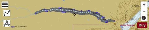
Loch Arkaig Fishing Map Stats | |
| Title | Loch Arkaig |
| Scale | 1:24000 |
| Area * | 3914.13 acres |
| Shoreline * | 27.70 miles |
| Min Longitude | -5.31 |
| Min Latitude | 56.95 |
| Max Longitude | -5.01 |
| Max Latitude | 56.98 |
| Edition Label 1 | |
| Edition Label 2 | |
| Edition Label 3 | |
| Id | II_SCOT_74400572_0_scot |
| Country | Inland Europe |
| Projection | Mercator |
| * some Stats may include nearby/connecting waterbodies | |
| |||||||||||||||||||||||||||||||||||||||||||||||||||||||||||||||||||||||||||||||||||||||||||||||||||||||
|